
Page 61 - Digital Analysis of Remotely Sensed Imagery
P. 61
34 Cha pte r T w o
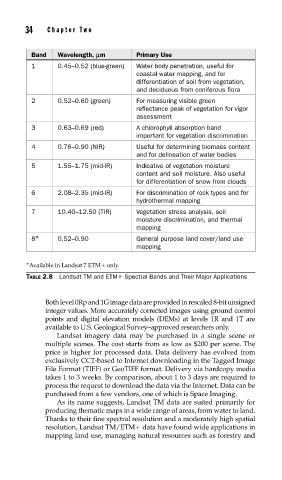
Band Wavelength, lm Primary Use
1 0.45–0.52 (blue-green) Water body penetration, useful for
coastal water mapping, and for
differentiation of soil from vegetation,
and deciduous from coniferous flora
2 0.52–0.60 (green) For measuring visible green
reflectance peak of vegetation for vigor
assessment
3 0.63–0.69 (red) A chlorophyll absorption band
important for vegetation discrimination
4 0.76–0.90 (NIR) Useful for determining biomass content
and for delineation of water bodies
5 1.55–1.75 (mid-IR) Indicative of vegetation moisture
content and soil moisture. Also useful
for differentiation of snow from clouds
6 2.08–2.35 (mid-IR) For discrimination of rock types and for
hydrothermal mapping
7 10.40–12.50 (TIR) Vegetation stress analysis, soil
moisture discrimination, and thermal
mapping
8 ∗ 0.52–0.90 General purpose land cover/land use
mapping
∗ Available in Landsat 7 ETM only.
TABLE 2.8 Landsat TM and ETM Spectral Bands and Their Major Applications
Both level 0Rp and 1G image data are provided in rescaled 8-bit unsigned
integer values. More accurately corrected images using ground control
points and digital elevation models (DEMs) at levels 1R and 1T are
available to U.S. Geological Survey–approved researchers only.
Landsat imagery data may be purchased in a single scene or
multiple scenes. The cost starts from as low as $200 per scene. The
price is higher for processed data. Data delivery has evolved from
exclusively CCT-based to Internet downloading in the Tagged Image
File Format (TIFF) or GeoTIFF format. Delivery via hardcopy media
takes 1 to 3 weeks. By comparison, about 1 to 3 days are required to
process the request to download the data via the Internet. Data can be
purchased from a few vendors, one of which is Space Imaging.
As its name suggests, Landsat TM data are suited primarily for
producing thematic maps in a wide range of areas, from water to land.
Thanks to their fine spectral resolution and a moderately high spatial
resolution, Landsat TM/ETM data have found wide applications in
mapping land use, managing natural resources such as forestry and