
Page 59 - Digital Analysis of Remotely Sensed Imagery
P. 59
32 Cha pte r T w o
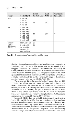
Spatial Swath Quantization
Sensor Spectral Band Resolution, m Width, km Level, bits
MSS 4: 0.5–0.6
5: 0.6–0.7
6: 0.7–0.8 79 185 7
7: 0.8–1.1
TM 1: 0.45–0.52
2: 0.52–0.60
3: 0.63–0.69
4: 0.76–0.90 30 185 8
5: 1.55–1.75
7: 2.08–2.35
6: 10.4–12.5 120
Landsat 7 PAN: 0.52–0.90 15
& ETM+ 6: 10.4–12.5 60
(15/04/99) (the remaining
bands are the
same as TM’s)
TABLE 2.6 Characteristics of Landsat MSS and TM Imagery
that their images have several improved qualities over imagery form
Landsats 1 to 3. Since the RBV sensor was not successful, it was
dropped from these two satellites. The MSS sensor had exactly the
same properties as before. Added to these satellites was a new sensor
called Thematic Mapper (TM). TM imagery is recorded in seven
spectral bands at a spatial resolution of 30 m except band 6, which has
a spatial resolution of 120 m. The wavelength range of these bands
and their primary uses are provided in Table 2.8.
The newest satellite in the series is Landsat 7 launched on April 15,
1999 (Landsat 6 failed soon after launch). Carried on board was a new
sensor called Enhanced TM Plus (ETM ). It has a few improvements
over its predecessors, such as a panchromatic band (band 8) at a spatial
resolution of 15 m. Besides, the spatial resolution of the TIR band
(band 6) was refined from 120 to 60 m. All the seven multispectral
bands have maintained the same wavelengths (Table 2.8). The ground
area covered per scene still stays at 185 185 km .
2
Landsat 7 ETM data are available to the general public at two
levels, 0Rp and 1G. Level 0Rp data are raw data that have not been
corrected for radiometric and geometric distortions except that scan lines
are reversed and nominally aligned. Level 1G data have been corrected
for systematic distortions, such as radiometric calibration and geometric
transformation to a user-specified projection. Such geometrically
corrected images have a typical accuracy of <250 m in low-relief areas.