
Page 56 - Digital Analysis of Remotely Sensed Imagery
P. 56
Overview of Remotely Sensed Data 29
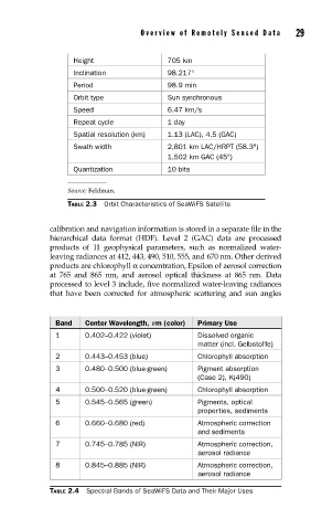
Height 705 km
Inclination 98.217°
Period 98.9 min
Orbit type Sun synchronous
Speed 6.47 km/s
Repeat cycle 1 day
Spatial resolution (km) 1.13 (LAC), 4.5 (GAC)
Swath width 2,801 km LAC/HRPT (58.3°)
1,502 km GAC (45°)
Quantization 10 bits
Source: Feldman.
TABLE 2.3 Orbit Characteristics of SeaWiFS Satellite
calibration and navigation information is stored in a separate file in the
hierarchical data format (HDF). Level 2 (GAC) data are processed
products of 11 geophysical parameters, such as normalized water-
leaving radiances at 412, 443, 490, 510, 555, and 670 nm. Other derived
products are chlorophyll α concentration, Epsilon of aerosol correction
at 765 and 865 nm, and aerosol optical thickness at 865 nm. Data
processed to level 3 include, five normalized water-leaving radiances
that have been corrected for atmospheric scattering and sun angles
Band Center Wavelength, mm (color) Primary Use
1 0.402–0.422 (violet) Dissolved organic
matter (incl. Gelbstoffe)
2 0.443–0.453 (blue) Chlorophyll absorption
3 0.480–0.500 (blue-green) Pigment absorption
(Case 2), K(490)
4 0.500–0.520 (blue-green) Chlorophyll absorption
5 0.545–0.565 (green) Pigments, optical
properties, sediments
6 0.660–0.680 (red) Atmospheric correction
and sediments
7 0.745–0.785 (NIR) Atmospheric correction,
aerosol radiance
8 0.845–0.885 (NIR) Atmospheric correction,
aerosol radiance
TABLE 2.4 Spectral Bands of SeaWiFS Data and Their Major Uses