
Page 54 - Digital Analysis of Remotely Sensed Imagery
P. 54
Overview of Remotely Sensed Data 27
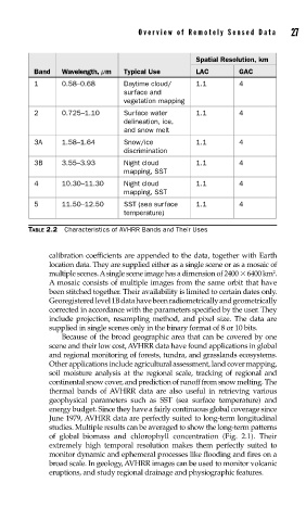
Spatial Resolution, km
Band Wavelength, μm Typical Use LAC GAC
1 0.58–0.68 Daytime cloud/ 1.1 4
surface and
vegetation mapping
2 0.725–1.10 Surface water 1.1 4
delineation, ice,
and snow melt
3A 1.58–1.64 Snow/ice 1.1 4
discrimination
3B 3.55–3.93 Night cloud 1.1 4
mapping, SST
4 10.30–11.30 Night cloud 1.1 4
mapping, SST
5 11.50–12.50 SST (sea surface 1.1 4
temperature)
TABLE 2.2 Characteristics of AVHRR Bands and Their Uses
calibration coefficients are appended to the data, together with Earth
location data. They are supplied either as a single scene or as a mosaic of
2
multiple scenes. A single scene image has a dimension of 2400 6400 km .
A mosaic consists of multiple images from the same orbit that have
been stitched together. Their availability is limited to certain dates only.
Georegistered level 1B data have been radiometrically and geometrically
corrected in accordance with the parameters specified by the user. They
include projection, resampling method, and pixel size. The data are
supplied in single scenes only in the binary format of 8 or 10 bits.
Because of the broad geographic area that can be covered by one
scene and their low cost, AVHRR data have found applications in global
and regional monitoring of forests, tundra, and grasslands ecosystems.
Other applications include agricultural assessment, land cover mapping,
soil moisture analysis at the regional scale, tracking of regional and
continental snow cover, and prediction of runoff from snow melting. The
thermal bands of AVHRR data are also useful in retrieving various
geophysical parameters such as SST (sea surface temperature) and
energy budget. Since they have a fairly continuous global coverage since
June 1979, AVHRR data are perfectly suited to long-term longitudinal
studies. Multiple results can be averaged to show the long-term patterns
of global biomass and chlorophyll concentration (Fig. 2.1). Their
extremely high temporal resolution makes them perfectly suited to
monitor dynamic and ephemeral processes like flooding and fires on a
broad scale. In geology, AVHRR images can be used to monitor volcanic
eruptions, and study regional drainage and physiographic features.