
Page 60 - Digital Analysis of Remotely Sensed Imagery
P. 60
Overview of Remotely Sensed Data 33
Field of view
Satellite
motion
Direction of
scanning
79 m
79 m
185 km
(2340 lines)
185 km
(3240 pixels per line)
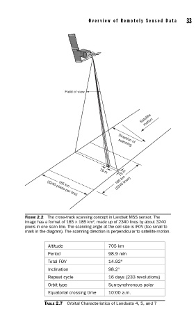
FIGURE 2.2 The cross-track scanning concept in Landsat MSS sensor. The
2
image has a format of 185 × 185 km , made up of 2340 lines by about 3240
pixels in one scan line. The scanning angle at the cell size is IFOV (too small to
mark in the diagram). The scanning direction is perpendicular to satellite motion.
Altitude 705 km
Period 98.9 min
Total FOV 14.92°
Inclination 98.2°
Repeat cycle 16 days (233 revolutions)
Orbit type Sun-synchronous polar
Equatorial crossing time 10:00 a.m.
TABLE 2.7 Orbital Characteristics of Landsats 4, 5, and 7