
Page 64 - Digital Analysis of Remotely Sensed Imagery
P. 64
Overview of Remotely Sensed Data 37
27∞
27∞
Nadir path
80 km
Off-nadir path
950 km
60 km
80 km
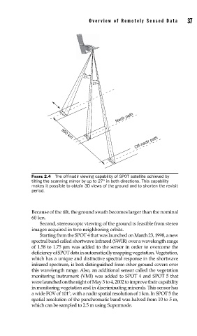
FIGURE 2.4 The off-nadir viewing capability of SPOT satellite achieved by
tilting the scanning mirror by up to 27° in both directions. This capability
makes it possible to obtain 3D views of the ground and to shorten the revisit
period.
Because of the tilt, the ground swath becomes larger than the nominal
60 km.
Second, stereoscopic viewing of the ground is feasible from stereo
images acquired in two neighboring orbits.
Starting from the SPOT 4 that was launched on March 23, 1998, a new
spectral band called shortwave infrared (SWIR) over a wavelength range
of 1.58 to 1.75 μm was added to the sensor in order to overcome the
deficiency of SPOT data in automatically mapping vegetation. Vegetation,
which has a unique and distinctive spectral response in the shortwave
infrared spectrum, is best distinguished from other ground covers over
this wavelength range. Also, an additional sensor called the vegetation
monitoring instrument (VMI) was added to SPOT 4 and SPOT 5 that
were launched on the night of May 3 to 4, 2002 to improve their capability
in monitoring vegetation and in discriminating minerals. This sensor has
a wide FOV of 101°, with a nadir spatial resolution of 1 km. In SPOT 5 the
spatial resolution of the panchromatic band was halved from 10 to 5 m,
which can be sampled to 2.5 m using Supermode.