
Page 69 - Digital Analysis of Remotely Sensed Imagery
P. 69
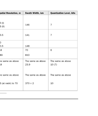
Quantization Level, bits   7  7  6  The same as above  10 (7)  The same as above  10


          Swath Width, km  146  141  148  70  810  The same as above  23.9  The same as above  370 × 2


          Spatial Resolution, m  73 (I)  36 (II)  23.5  20  70.5  5.8  189  The same as above  5.8  The same as above  56 (at nadir) to 70


          Spectral Band (lm)  0.45–0.52  0.52–0.59  0.62–0.68  0.77–0.86  0.52–0.59  0.62–0.68  0.77–0.86  The same as above  1.55–1.70  0.5–0.75  0.62–0.68  0.77–0.86  The same as above  B2: 0.52–0.59  B3: 0.62–0.68  B4: 0.77–0.86  The same as above  B2: 0.52–0.59  B3: 0.62–0.68  B4: 0.77–0.86  B5: 1.55–1.


          Sensor  LISS-I, II  LISS-III  LISS-III  PAN  WiFS  LISS-III  LISS-IV ∗  PAN mode  AWiFS ∗ The same sensor can work either in the LISS-IV or the PAN mode.  Characteristics of Sensors aboard the IRS Satellites


          Satellite  IRS-1A  IRS-1B  IRS-1C  IRS-1D  Resourcesat-1   TABLE 2.13


                                                                     41