
Page 82 - Digital Analysis of Remotely Sensed Imagery
P. 82
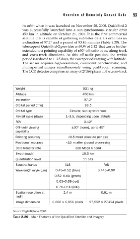
Overview of Remotely Sensed Data       53

               its orbit when it was launched on November 20, 2000. QuickBird-2
               was successfully launched into a sun-synchronous, circular orbit
               450 km in altitude on October 21, 2001. It is the first commercial
               satellite that is capable of gathering submeter data. Its orbit has an
               inclination of 97.2° and a period of 93.45 minutes (Table 2.20). The
               telescope of QuickBird-2 provides an FOV of 2.12º that can be further
               extended to a pointing capability of ±30° off nadir in the along-track
               and cross-track directions.  At this off-nadir position, the revisit
               period is reduced to 1–3.5 days, the exact period varying with latitude.
               The sensor acquires high-resolution, coincident panchromatic, and
               multispectral images simultaneously using pushbroom scanning.
               The CCD detector comprises an array of 27,568 pixels in the cross-track


            Weight                               931 kg
            Altitude                             450 km
            Inclination                          97.2°
            Orbital period (min)                  93.5
            Orbital type                  Circular, sun synchronous
            Revisit cycle (days)       1–3.5, depending upon latitude
            FOV                                  2.12°
            Off-nadir viewing              ±30° (norm), up to 45°
            capability
            Pointing accuracy           <0.5 mrad absolute per axis
            Positional accuracy        <15 m after ground processing
            Data transfer rate               320 Mbps X band
            Swath (nadir)                       16.5 km
            Quantization level                   11 bits
            Spectral bands             XLS                  PAN
            Wavelength range (μm)  0.45–0.52 (blue)      0.445–0.90
                                 0.52–0.60 (green)
                                  0.63–0.69 (red)
                                  0.76–0.90 (NIR)
            Spatial resolution at     2.4 m                0.61 m
            nadir
            Image dimension     6,888 × 6,856 pixels  27,552 × 27,424 pixels

          Source: DigitalGlobe, 2007.
          TABLE 2.20  Main Features of the QuickBird Satellite and Imagery