
Page 81 - Digital Analysis of Remotely Sensed Imagery
P. 81
52 Cha pte r T w o
The fine spatial resolution of IKONOS images makes them the
ideal candidates in applications that require detailed and highly
accurate data, such as cadastral and infrastructure mapping, as
well as detailed urban analysis. Panchromatic data of 1-m resolution
are useful for mapping at a scale up to 1:5000. Stereoscopic pairs of
PAN imagery allow construction of DEMs from them. Other
applications of IKONOS data include planning, agriculture, and
even insurance. In planning, IKONOS data are suited to plan
housing development. In urban areas IKONOS imagery can be
used to update street networks, plan urban transport, and manage
utilities (Fig. 2.8). Pipelines and power lines, rubbish dumps, and
dams can all be positioned using the fine resolution data. IKONOS
images also play an important role in precision farming, such as
pinpointing the spots in need of special treatment. For insurance
purposes, the imagery can be used for assessing damage to
properties and crops caused by natural disasters such as flooding,
drought, and tornadoes.
2.4.2 QuickBird
There are three satellites in this series. The first, called EarlyBird, was
launched by DigitalGlobe in late 1997, but it malfunctioned shortly
after being sent into orbit. The second, QuickBird-1, failed to reach
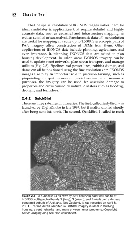
FIGURE 2.8 A subscene (474 rows by 581 columns) color composite of
IKONOS multispectral bands 2 (blue), 3 (green), and 4 (red) over a densely
populated suburb of Auckland, New Zealand. It was recorded on April 8,
2001. The fi ne detail exhibited in IKONOS imagery is ideal in studying
housing, street networks, and many environmental problems. (Copyright
Space Imaging Inc.) See also color insert.