
Page 96 - Digital Analysis of Remotely Sensed Imagery
P. 96
Overview of Remotely Sensed Data 67
2.6 Radar Data
Because of the strong penetration capability of microwave radiation,
radar remote sensing is operational for the entire Earth’s surface
regardless of the frequency and volatility of cloud cover. In fact, it is
the only operational remote sensing system in mapping persistently
cloudy regions. Radar data are hence a useful supplement to optical
remote sensing data. In this section, four major spaceborne radar
remote sensing programs (JERS, ERS, Radarsat, and EnviSat) are
briefly surveyed, with the emphasis placed on system parameters
and image properties.
2.6.1 JERS Data
JERS-1 was launched into a sun-synchronous orbit on February 11,
1992. It has an orbital inclination of 97.7° and a period of 94 minutes.
At an altitude of 568 km, the satellite completely covers the Earth in
44 days. The payload of JERS-1 encompasses optical sensors and a
SAR sensor. The former collect data in eight spectral bands, covering
the wavelength range 0.52–2.4 μm. The SAR sensor operating in
L-band (1.3 GHz, 23 cm) acquires imagery at a swath width of 75 km
2
and a spatial resolution of 18 18 m . JERS SAR imagery is best at
monitoring land use, glacier extent, snow cover, surface topography,
and ocean currents and waves. Other potential applications include
national land survey, agriculture, forestry, fishery, and environmental
protection, and coastal monitoring.
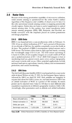
2.6.2 ERS Data
The first Earth Resource Satellite (ERS-1) was launched into a near-polar
orbit of about 780 km on July 17, 1991, by the European Space Agency,
followed by ERS-2 on April 20, 1995. Both satellites are designed to
acquire data about the Earth’s ocean, ice, and land resources. ERS-1 has
an orbital inclination of 98.52° at a period of 100 minutes. Its return
period can be adjusted from 3 days to 168 days to meet different data
acquisition requirements at different geographic locations (Table 2.28).
Accordingly, other parameters such as altitude and orbital inclination
3 days 35 days 168 days
Mean altitudeH (km) 785 782 770
Orbital inclination (°) 98.516 98.543 98.491
Orbits per cycle 43 501 2,411
Semimajor axis (km) 7,153.138 7,159.496 7,147.191
TABLE 2.28 Orbital Parameters of ERS-1 Satellite at Three Repeat Cycles