
Page 60 - Earth's Climate Past and Future
P. 60
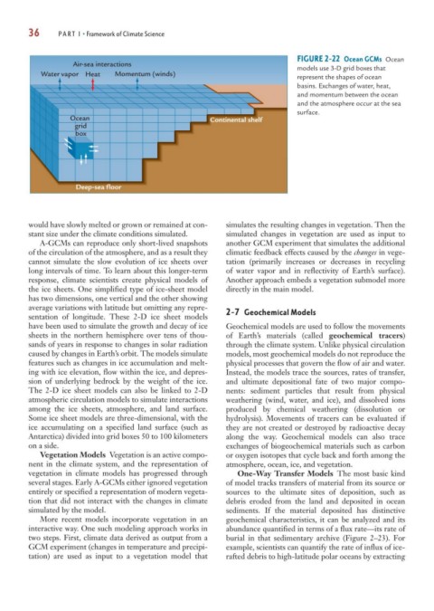
36      PART I • Framework of Climate Science


                                                                               FIGURE 2-22 Ocean GCMs Ocean
                    Air-sea interactions
                                                                               models use 3-D grid boxes that
            Water vapor  Heat  Momentum (winds)                                represent the shapes of ocean
                                                                               basins. Exchanges of water, heat,
                                                                               and momentum between the ocean
                                                                               and the atmosphere occur at the sea
                                                                               surface.
                   Ocean                                Continental shelf
                    grid
                     box


                     Deep-sea floor


        would have slowly melted or grown or remained at con-  simulates the resulting changes in vegetation. Then the
        stant size under the climate conditions simulated.  simulated changes in vegetation are used as input to
           A-GCMs can reproduce only short-lived snapshots  another GCM experiment that simulates the additional
        of the circulation of the atmosphere, and as a result they  climatic feedback effects caused by the changes in vege-
        cannot simulate the slow evolution of ice sheets over  tation (primarily increases or decreases in recycling
        long intervals of time. To learn about this longer-term  of water vapor and in reflectivity of Earth’s surface).
        response, climate scientists create physical models of  Another approach embeds a vegetation submodel more
        the ice sheets. One simplified type of ice-sheet model  directly in the main model.
        has two dimensions, one vertical and the other showing
        average variations with latitude but omitting any repre-  2-7 Geochemical Models
        sentation of longitude. These 2-D ice sheet models
        have been used to simulate the growth and decay of ice  Geochemical models are used to follow the movements
        sheets in the northern hemisphere over tens of thou-  of Earth’s materials (called  geochemical tracers)
        sands of years in response to changes in solar radiation  through the climate system. Unlike physical circulation
        caused by changes in Earth’s orbit. The models simulate  models, most geochemical models do not reproduce the
        features such as changes in ice accumulation and melt-  physical processes that govern the flow of air and water.
        ing with ice elevation, flow within the ice, and depres-  Instead, the models trace the sources, rates of transfer,
        sion of underlying bedrock by the weight of the ice.  and ultimate depositional fate of two major compo-
        The 2-D ice sheet models can also be linked to 2-D  nents: sediment particles that result from physical
        atmospheric circulation models to simulate interactions  weathering (wind, water, and ice), and dissolved ions
        among the ice sheets, atmosphere, and land surface.  produced by chemical weathering (dissolution or
        Some ice sheet models are three-dimensional, with the  hydrolysis). Movements of tracers can be evaluated if
        ice accumulating on a specified land surface (such as  they are not created or destroyed by radioactive decay
        Antarctica) divided into grid boxes 50 to 100 kilometers  along the way. Geochemical models can also trace
        on a side.                                          exchanges of biogeochemical materials such as carbon
           Vegetation Models Vegetation is an active compo-  or oxygen isotopes that cycle back and forth among the
        nent in the climate system, and the representation of  atmosphere, ocean, ice, and vegetation.
        vegetation in climate models has progressed through    One-Way Transfer Models The most basic kind
        several stages. Early A-GCMs either ignored vegetation  of model tracks transfers of material from its source or
        entirely or specified a representation of modern vegeta-  sources to the ultimate sites of deposition, such as
        tion that did not interact with the changes in climate  debris eroded from the land and deposited in ocean
        simulated by the model.                             sediments. If the material deposited has distinctive
           More recent models incorporate vegetation in an  geochemical characteristics, it can be analyzed and its
        interactive way. One such modeling approach works in  abundance quantified in terms of a flux rate—its rate of
        two steps. First, climate data derived as output from a  burial in that sedimentary archive (Figure 2–23). For
        GCM experiment (changes in temperature and precipi-  example, scientists can quantify the rate of influx of ice-
        tation) are used as input to a vegetation model that  rafted debris to high-latitude polar oceans by extracting