
Page 236 - Fundamentals of Ocean Renewable Energy Generating Electricity From The Sea
P. 236
Ocean Modelling for Resource Characterization Chapter | 8 225
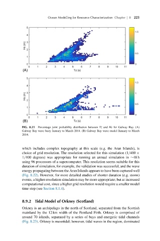
FIG. 8.21 Percentage joint probability distribution between Tz and Hs for Galway Bay. (A)
Galway Bay wave buoy January to March 2014. (B) Galway Bay wave model January to March
2014.
which includes complex topography at this scale (e.g. the Aran Islands), is
choice of grid resolution. The resolution selected for this simulation (1/400 ×
1/400 degrees) was appropriate for running an annual simulation in ∼48 h
using 96 processors of a supercomputer. This resolution seems suitable for this
duration of simulation, for example, the validation was successful, and the wave
energy propagating between the Aran Islands appears to have been captured well
(Fig. 8.22). However, for more detailed studies of shorter duration (e.g. storm)
events, a higher-resolution simulation may be more appropriate; but at increased
computational cost, since a higher grid resolution would require a smaller model
time step (see Section 8.1.4).
8.9.2 Tidal Model of Orkney (Scotland)
Orkney is an archipelago in the north of Scotland, separated from the Scottish
mainland by the 12 km width of the Pentland Firth. Orkney is comprised of
around 70 islands, separated by a series of bays and energetic tidal channels
(Fig. 8.23). Orkney is mesotidal; however, tidal waves in the region, dominated