
Page 143 - Geochemical Anomaly and Mineral Prospectivity Mapping in GIS
P. 143
142 Chapter 5
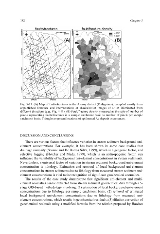
Fig. 5-13. (A) Map of faults/fractures in the Aroroy district (Philippines), compiled mostly from
unpublished literature and interpretations of shaded-relief images of DEM illuminated from
different directions (e.g., Fig. 4-11). (B) Fault/fracture density measured as the ratio of number of
pixels representing faults/fractures in a sample catchment basin to number of pixels per sample
catchment basin. Triangles represent locations of epithermal Au deposit occurrences.
DISCUSSION AND CONCLUSIONS
There are various factors that influence variation in stream sediment background uni-
element concentrations. For example, it has been shown in some case studies that
drainage sinuosity (Seoane and De Barros Silva, 1999), which is a geogenic factor, and
selective logging (Fletcher and Muda, 1999), which is an anthropogenic factor, can
influence the variability of background uni-element concentrations in stream sediments.
Nevertheless, a universal factor of variation in stream sediment background uni-element
concentration is lithology. Estimation and removal of local background uni-element
concentrations in stream sediments due to lithology from measured stream sediment uni-
element concentrations is vital to the recognition of significant geochemical anomalies.
The results of the case study demonstrate that significant uni-element and multi-
element anomalies can be extracted from stream sediment geochemical data through a 5-
stage GIS-based methodology involving: (1) estimation of local background uni-element
concentrations due to lithology per sample catchment basin; (2) removal of estimated
local background uni-element concentrations due to lithology from measured uni-
element concentrations, which results in geochemical residuals; (3) dilution-correction of
geochemical residuals using a modified formula from the relation proposed by Hawkes