
Page 147 - Geochemical Anomaly and Mineral Prospectivity Mapping in GIS
P. 147
148 Chapter 6
epithermal Au deposits in the case study area. Faults/fractures in the case study area
(Fig. 5-13) are also used as input data in the spatial association analysis in order to
define prospectivity recognition criteria representing structural controls on epithermal
Au mineralisation. However, let us proceed first with the analysis of the spatial
distribution of occurrences of the epithermal Au deposits in the case study area in order
to gain insights into their geologic controls.
SPATIAL DISTRIBUTION OF MINERAL DEPOSITS
In most case studies of mineral prospectivity mapping, the locations of known
mineral deposits of the type sought are depicted as points. Thus, a univariate point map
(of mineral deposits of the type sought) is used as input data in the analysis of the spatial
distribution of mineral deposits. Three methods to characterise the spatial distribution of
occurrences of mineral deposits of the type sought are explained and demonstrated here:
point pattern analysis, fractal analysis and Fry analysis.
Point pattern analysis
Point pattern analysis is a technique that is used to obtain information about the
arrangement of point data in space to be able to make an inference about the spatial
distribution of occurrences of certain geo-objects represented as points. There are three
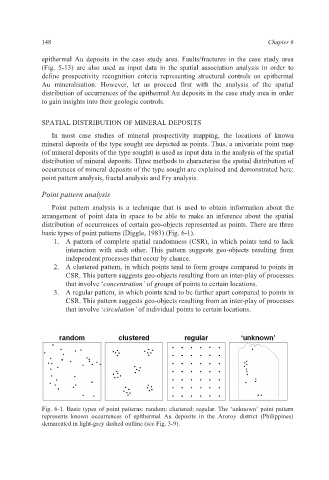
basic types of point patterns (Diggle, 1983) (Fig. 6-1).
1. A pattern of complete spatial randomness (CSR), in which points tend to lack
interaction with each other. This pattern suggests geo-objects resulting from
independent processes that occur by chance.
2. A clustered pattern, in which points tend to form groups compared to points in
CSR. This pattern suggests geo-objects resulting from an inter-play of processes
that involve ‘concentration’ of groups of points to certain locations.
3. A regular pattern, in which points tend to be farther apart compared to points in
CSR. This pattern suggests geo-objects resulting from an inter-play of processes
that involve ‘circulation’ of individual points to certain locations.
Fig. 6-1. Basic types of point patterns: random; clustered; regular. The ‘unknown’ point pattern
represents known occurrences of epithermal Au deposits in the Aroroy district (Philippines)
demarcated in light-grey dashed outline (see Fig. 3-9).