
Page 49 - Geochemical Anomaly and Mineral Prospectivity Mapping in GIS
P. 49
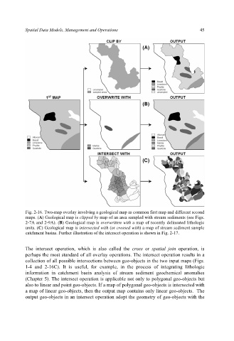
Spatial Data Models, Management and Operations                        45


           Fig. 2-16. Two-map overlay involving a geological map as common first map and different second
           maps. (A) Geological map is clipped by map of an area sampled with stream sediments (see Figs.
           2-7A and 2-9A). (B) Geological map is overwritten with a map of recently delineated lithologic
           units. (C) Geological map is intersected with (or crossed with) a map of stream sediment sample
           catchment basins. Further illustration of the intersect operation is shown in Fig. 2-17.


           The intersect operation, which is also called the  cross or  spatial join operation, is
           perhaps the most standard of all overlay operations. The intersect operation results in a
           collection of all possible intersections between geo-objects in the two input maps (Figs.
           1-4 and  2-16C). It is  useful, for  example, in the  process of integrating lithologic
           information in catchment basin analysis of stream sediment geochemical anomalies
           (Chapter 5). The intersect operation is applicable not only to polygonal geo-objects but
           also to linear and point geo-objects. If a map of polygonal geo-objects is intersected with
           a map of linear geo-objects, then the output map contains only linear geo-objects.  The
           output geo-objects in an intersect operation adopt the geometry of geo-objects with the