
Page 50 - Geochemical Anomaly and Mineral Prospectivity Mapping in GIS
P. 50
46 Chapter 2
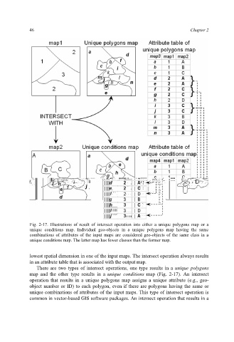
Fig. 2-17. Illustrations of result of intersect operation into either a unique polygons map or a
unique conditions map. Individual geo-objects in a unique polygons map having the same
combinations of attributes of the input maps are considered geo-objects of the same class in a
unique conditions map. The latter map has fewer classes than the former map.
lowest spatial dimension in one of the input maps. The intersect operation always results
in an attribute table that is associated with the output map.
There are two types of intersect operations, one type results in a unique polygons
map and the other type results in a unique conditions map (Fig. 2-17). An intersect
operation that results in a unique polygons map assigns a unique attribute (e.g., geo-
object number or ID) to each polygon, even if there are polygons having the same or
unique combinations of attributes of the input maps. This type of intersect operation is
common in vector-based GIS software packages. An intersect operation that results in a