
Page 202 - Geothermal Energy Renewable Energy and The Environment
P. 202
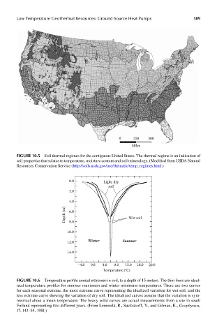
Low Temperature Geothermal Resources: Ground Source Heat Pumps              189


                                                        0     250    500
                                                             Miles

            FIGUre 10.5  Soil thermal regimes for the contiguous United States. The thermal regime is an indication of
            soil properties that relates to temperature, moisture content and soil mineralogy. (Modified from USDA Natural
            Resources Conservation Service (http://soils.usda.gov/use/thematic/temp_regimes.html.)


                                  0.0            Light, dry
                                                   soil
                                  2.0

                                  4.0
                                 Depth (m)  6.0             Wet soil

                                  8.0

                                  10.0
                                  12.0     Winter        Summer

                                  14.0

                                      –4.0  0.0  4.0  8.0  12.0  16.0  20.0
                                                 Temperature (°C)

            FIGUre 10.6  Temperature profile annual extremes in soil, to a depth of 15 meters. The thin lines are ideal-
            ized temperature profiles for summer maximum and winter minimum temperatures. There are two curves
            for each seasonal extreme, the more extreme curve representing the idealized variation for wet soil, and the
            less extreme curve showing the variation of dry soil. The idealized curves assume that the variation is sym-
            metrical about a mean temperature. The heavy solid curves are actual measurements from a site in south
            Finland representing two different years. (From Lemmelä, R., Sucksdorff, Y., and Gilman, K., Geophysica,
            17, 143–54, 1981.)