
Page 38 - Geothermal Energy Renewable Energy and The Environment
P. 38
Sources of Geothermal Heat: Earth as a Heat Engine 21
One of the primary stumbling blocks to the acceptance of the concept of a mobile crust was the
absence of a convincing mechanism for driving the movement. This issue was eventually resolved
after the Second World War when oceanographic research vessels were outfitted with magnetome-
ters that were originally intended to be used to detect submarines during the war. Evidence obtained
from oceanic surveys documented the presence of a globe-encircling mountain chain that became
known as the mid-ocean ridge system. As the magnetometer-equipped vessels cruised the world
ocean, they discovered unexpected patterns of magnetic anomalies that paralleled the ocean ridge
system, and that extended for hundreds of miles on either side of them. It was quickly recognized
that the anomaly pattern on one side of the ridge system was precisely mirrored by the anomaly
pattern on the other side of the ridge. The only explanation for this symmetry was that the ocean
crust must be forming at the ridges and spreading away from it. For that to be the case, it was postu-
lated that the mantle must be upwelling at the mid-ocean ridge system. That upwelling process was
bringing hot, deep mantle rocks to the surface, which resulted in melting of the hot rock as it rose
to shallower levels in the Earth where pressures were lower. This process of hot, upwelling mantle
was a classic example of convection. The places where the upwelling convection cells intersect the
surface of the Earth are called spreading centers because they define those places where crust forms
and migrates away to either side of the ridge system.
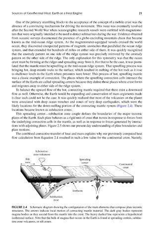
To balance the upward flow of the hot, convecting mantle required that there exist a downward
flow as well. Otherwise, the Earth would be expanding and conservation of mass arguments made
it clear such could not be the case. It was quickly realized that most of the volcanoes on the planet
were associated with deep ocean trenches and zones of very deep earthquakes, which were the
likely locations for the down-welling portion of the convecting mantle system (Figure 2.4). These
locations became known as subduction zones.
This spreading center—subduction zone couple defines the boundaries of the major tectonic
plates of the Earth. Each plate behaves as a rigid unit of crust that moves in response to forces from
the underlying convection cells in the mantle, as well as in response to forces generated by interac-
tions with adjoining plates. Figure 2.5 shows our present day understanding of plate boundaries and
plate motions.
The combined convective transfer of heat and mass explains why our previously computed heat
flow calculation from Equation 2.4 resulted in such a low value for the continental crust. Namely,
Subduction
zone volcanoes
Rift Spreading
zone center
Continental
crust
Isotherm
Subduction
zone
FIGUre 2.4 Schematic diagram showing the configuration of the main elements that compose plate tectonic
structures. The arrows indicate local motion of convecting mantle material. The dark gray bodies represent
magma bodies as they ascend from the mantle into the crust. The heavy dashed line represents a hypothetical
isothermal surface. Note that the bulk of magma that occurs in the Earth is found at spreading centers, subduc-
tion zone volcanoes, or rift zones.