
Page 319 - Hydrogeology Principles and Practice
P. 319
HYDC08 12/5/05 5:32 PM Page 302
302 Chapter Eight
widescale destruction of wetland habitat can occur,
as illustrated graphically by the Florida Everglades
(Box 8.6).
8.5 Climate change and groundwater resources
The global climate is undoubtedly changing. Instru-
mental records dating back to 1860 show that the
globally averaged surface air temperature has risen
by about 0.6°C since the beginning of the twentieth
century, with about 0.4°C of this warming occurring
since the 1970s (Fig. 8.15). The year 1998 was the
warmest year recorded and 2003 the third warmest.
Globally, the 1990s were the warmest decade in the
last 100 years and it is likely that the last 100 years was
the warmest century in the last millennium (Hulme
et al. 2002). Other evidence for changes in global clim-
ate include more intense rainfall events over many
Northern Hemisphere mid- to-high latitude land areas
and a near world-wide decrease in mountain glacier
extent and ice mass.
In central England, the thermal growing season for
plants has lengthened by 1 month since 1900 and win-
ters over the last 200 years have become wetter relat-
ive to summers throughout the United Kingdom.
Also, a larger proportion of winter precipitation in all
regions now falls on heavy rainfall days than was the
case 50 years ago. Around the United Kingdom, and
adjusting for natural land movements, average sea
level is now about 10 cm higher than the level in 1900
(Hulme et al. 2002).
Climate change is influenced by both natural and
human causes. The Earth’s climate varies naturally as
a result of interactions between the ocean and atmo-
sphere, changes in the Earth’s orbit, fluctuations in
incoming solar radiation and volcanic activity. The
main human cause is probably the increasing emis-
sions of ‘greenhouse’ gases such as carbon dioxide,
methane, nitrous oxide and chlorofluorocarbons.
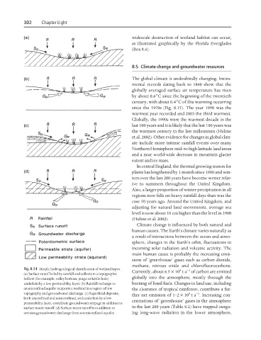
Fig. 8.14 Simple hydrogeological classification of wetland types. 9 −1
Currently, about 6.5 × 10 ta of carbon are emitted
(a) Surface runoff is fed by rainfall and collects in a topographic
globally into the atmosphere, mostly through the
hollow (for example, valley bottom, pingo or kettle hole)
underlain by a low permeability layer. (b) Rainfall recharge to burning of fossil fuels. Changes in land use, including
an unconfined aquifer supports a wetland in a region of low the clearance of tropical rainforest, contribute a fur-
topography and groundwater discharge. (c) Superficial deposits, 9 −1
ther net emission of 1–2 × 10 ta . Increasing con-
both unconfined and semiconfined, and underlain by a low
centrations of ‘greenhouse’ gases in the atmosphere
permeability layer, contribute groundwater seepage in addition to
in the last 200 years (Table 8.2) have trapped outgo-
surface water runoff. (d) Surface water runoff is in addition to
artesian groundwater discharge from a semiconfined aquifer. ing long-wave radiation in the lower atmosphere,