
Page 320 - Hydrogeology Principles and Practice
P. 320
HYDC08 12/5/05 5:32 PM Page 303
Groundwater resources and environmental management 303
Impact of groundwater abstraction on Redgrave and Lopham Fen, BO X
East Anglia, England 8.5
3
−1
Redgrave and Lopham Fen is an internationally important British and licensed to abstract 3600 m day in 1965. Warby’s Drain and
calcareous valley fen situated on the Norfolk and Suffolk border in the River Waveney were deep-dredged at this time, substantially
the peat-filled headwaters of the River Waveney (see Figs 1 & 2 for increasing channel capacity, with a sluice at the downstream end of
location and general aspect). The fen, covering 123 ha, is the largest Redgrave Fen installed to control outflows. As shown schematically
fen of its type in lowland Britain and was declared a Ramsar site in in Fig. 3b, the operation of the water company source led to the
1991. The largest part of the fen is covered by shallow peat sup- elimination of vertical groundwater seepage and the frequent dry-
porting a complex mosaic of reed and sedge beds, mixed species fen ing out of Warby’s Drain. The normal condition of perennial, high
and spring flushes. The fen is noted for its rare and precarious com- water levels with Chalk groundwater discharging through the fen,
munity of fen raft spiders. For nearly 40 years, the fen experienced
substantial ecological change, principally due to a change in the
groundwater flow regime relating to an adjacent water company
borehole.
The general geology of the fen consists of Cretaceous Chalk cov-
ered by glacial till, sands and gravels. The Chalk surface is incised by
a deep buried channel which is thought to be about 1 km wide
in the vicinity of the fen. With reference to Fig. 8.14, the fen is a
combination of wetland types (c) and (d). Before the late 1950s,
calcareous and nutrient-poor water rose under artesian pressure
from the semiconfined Chalk aquifer and seeped into the fen both
around the fen margins and within the peats (Fig. 3a). The extreme
heterogeneity of the superficial Quaternary deposits resulted in
great spatial variation in the quantity of rising Chalk water. The
interaction of base-poor water from marginal sands with the cal-
careous and acid peats produced local variation in soil chemistry
that supported a diverse mosaic of fen plant communities of high
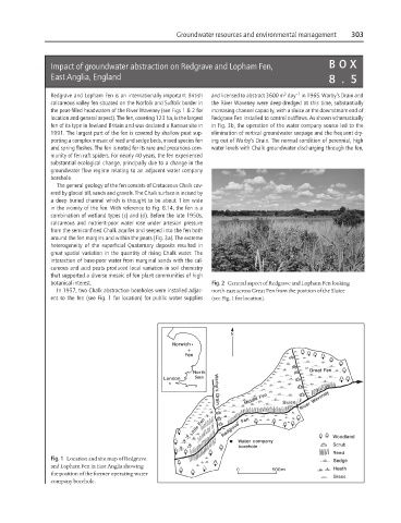
botanical interest. Fig. 2 General aspect of Redgrave and Lopham Fen looking
In 1957, two Chalk abstraction boreholes were installed adjac- north-east across Great Fen from the position of the Sluice
ent to the fen (see Fig. 1 for location) for public water supplies (see Fig. 1 for location).
Fig. 1 Location and site map of Redgrave
and Lopham Fen in East Anglia showing
the position of the former operating water
company borehole.