
Page 323 - Hydrogeology Principles and Practice
P. 323
HYDC08 12/5/05 5:32 PM Page 306
306 Chapter Eight
BO X
The Florida Everglades: a region under environmental stress
8.6
The Florida Everglades comprises part of the south Florida ecosys-
tem that formed during the last several thousand years during
the Holocene epoch. The ecosystem consists primarily of wetlands
and shallow-water habitats set in a subtropical environment
(McPherson & Halley 1997). The south Florida region is underlain
by a thick sequence of shallow marine carbonate sediments
deposited from the Cretaceous through to the early Tertiary as a
carbonate platform. Younger Tertiary deposits consist of shallow
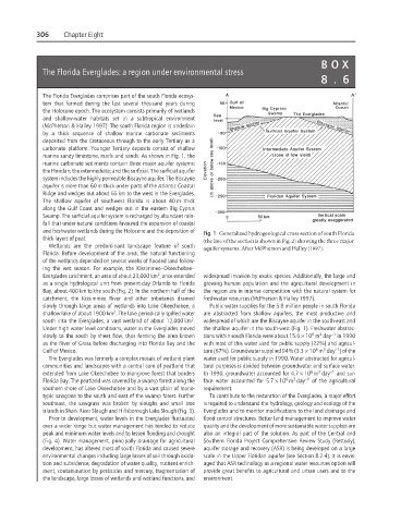
marine sandy limestone, marls and sands. As shown in Fig. 1, the
marine carbonate sediments contain three major aquifer systems:
the Floridan; the intermediate; and the surficial. The surficial aquifer
system includes the highly permeable Biscayne aquifer. The Biscayne
aquifer is more than 60 m thick under parts of the Atlantic Coastal
Ridge and wedges out about 65 km to the west in the Everglades.
The shallow aquifer of southwest Florida is about 40 m thick
along the Gulf Coast and wedges out in the eastern Big Cyprus
Swamp. The surficial aquifer system is recharged by abundant rain-
fall that under natural conditions favoured the expansion of coastal
and freshwater wetlands during the Holocene and the deposition of
Fig. 1 Generalized hydrogeological cross-section of south Florida
thick layers of peat.
(the line of the section is shown in Fig. 2) showing the three major
Wetlands are the predominant landscape feature of south
aquifer systems. After McPherson and Halley (1997).
Florida. Before development of the area, the natural functioning
of the wetlands depended on several weeks of flooded land follow-
ing the wet season. For example, the Kissimmee–Okeechobee–
2
Everglades catchment, an area of about 23,000 km , once extended widespread invasion by exotic species. Additionally, the large and
as a single hydrological unit from present-day Orlando to Florida growing human population and the agricultural development in
Bay, about 400 km to the south (Fig. 2). In the northern half of the the region are in intense competition with the natural system for
catchment, the Kissimmee River and other tributaries drained freshwater resources (McPherson & Halley 1997).
slowly through large areas of wetlands into Lake Okeechobee, a Public water supplies for the 5.8 million people in south Florida
2
shallow lake of about 1900 km . The lake periodically spilled water are abstracted from shallow aquifers, the most productive and
2
south into the Everglades, a vast wetland of about 12,000 km . widespread of which are the Biscayne aquifer in the south-east and
Under high water level conditions, water in the Everglades moved the shallow aquifer in the south-west (Fig. 1). Freshwater abstrac-
6
3
−1
slowly to the south by sheet flow, thus forming the area known tions within south Florida were about 15.6 × 10 m day in 1990
as the River of Grass before discharging into Florida Bay and the with most of this water used for public supply (22%) and agricul-
3
6
−1
Gulf of Mexico. ture (67%). Groundwater supplied 94% (3.3 × 10 m day ) of the
The Everglades was formerly a complex mosaic of wetland plant water used for public supply in 1990. Water abstracted for agricul-
communities and landscapes with a central core of peatland that tural purposes is divided between groundwater and surface water.
3
6
extended from Lake Okeechobee to mangrove forest that borders In 1990, groundwater accounted for 4.7 × 10 m day −1 and sur-
6
3
Florida Bay. The peatland was covered by a swamp forest along the face water accounted for 5.7 × 10 m day −1 of the agricultural
southern shore of Lake Okeechobee and by a vast plain of mono- requirement.
typic sawgrass to the south and east of the swamp forest. Further To contribute to the restoration of the Everglades, a major effort
southeast, the sawgrass was broken by sloughs and small tree is required to understand the hydrology, geology and ecology of the
islands in Shark River Slough and Hillsborough Lake Slough (Fig. 3). Everglades and to monitor modifications to the land drainage and
Prior to development, water levels in the Everglades fluctuated flood control structures. Better land management to improve water
over a wider range but water management has tended to reduce quality and the development of more sustainable water supplies are
peak and minimum water levels and to lessen flooding and drought also an integral part of the solution. As part of the Central and
(Fig. 4). Water management, principally drainage for agricultural Southern Florida Project Comprehensive Review Study (Restudy),
development, has altered most of south Florida and caused severe aquifer storage and recovery (ASR) is being developed on a large
environmental changes including large losses of soil through oxida- scale in the Upper Floridan aquifer (see Section 8.2.4). It is envis-
tion and subsidence, degradation of water quality, nutrient enrich- aged that ASR technology as a regional water resources option will
ment, contamination by pesticides and mercury, fragmentation of provide great benefits to agricultural and urban users and to the
the landscape, large losses of wetlands and wetland functions, and environment.