
Page 325 - Hydrogeology Principles and Practice
P. 325
HYDC08 12/5/05 5:32 PM Page 308
308 Chapter Eight
BO X
Continued
8.6
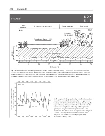
Fig. 3 Generalized section of the Everglades wetlands in the Shark River Slough (see Fig. 2 for location). Peat develops in wetlands
that are flooded for extensive periods during the year and calcitic muds develop in wetlands where the periods of flooded landed are
shorter and limestone is near the surface. The Everglades has been a dynamic environment with numerous shifts between marl- and
peat-forming marshes and between sawgrass marshes and water-lily sloughs. After McPherson and Halley (1997).
Fig. 4 Long-term hydrograph showing water level fluctuations
at a well in southern Dade County (see Fig. 2 for approximate
location), 1932–1939 and 1982–1989. Drainage of the Everglades
began in the early 1880s and continued into the 1960s with the
purpose of reducing the risk of flooding and drought and so
opening land for agricultural development south of Lake
Okeechobee. The effect of water management in the Everglades
has been to reduce peak and minimum water levels in the
Everglades, as illustrated in the well hydrograph. After
McPherson and Halley (1997).