
Page 204 - Introduction to Mineral Exploration
P. 204
9: MINERAL EXPLORATION DATA 187
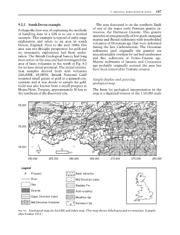
9.2.2 South Devon example The area discussed is on the southern flank
of one of the major early Permian granite in-
Perhaps the best way of explaining the methods trusives, the Dartmoor Granite. This granite
of handling data in a GIS is to use a worked intrudes an area generally of low grade marginal
example. This example is typical of early stage marine and fluvial sediments with interbedded
exploration and refers to an area in south volcanics of Devonian age that were deformed
Devon, England. Prior to the mid 1980s this during the late Carboniferous. The Devonian
area was not thought prospective for gold and sediments (and originally the granite) are
no systematic exploration had been under- unconformably overlain by red-bed sandstones
taken. The British Geological Survey had long and fine sediments of Permo-Triassic age.
been active in the area and had investigated the Marine sediments of Jurassic and Cretaceous
area of basic volcanics in the north of Fig. 9.3 age probably originally covered the area but
for its base metal potential. The initial orienta- have been removed by Tertiary erosion.
tion samples derived from acid volcanics
(266,000E, 49,000N, British National Grid)
returned small grains of gold in a panned con- Simple display and querying:
centrate and it was decide to sample for gold. geological map
Gold was also known from a small prospect at
Hopes Nose, Torquay, approximately 30 km to The basis for geological interpretation in the
the northeast of the discovery site. area is a digitized version of the 1:50,000 scale
55,000
50,000
45,000
5
N km
250,000 255,000 260,000 265,000 270,000 275,000 280,000
Legend
Prospect Basic volcanics
River Mid Devonian slates
Sea
Staddon Fm.
Dolerite Acid volcanics
Upper Devonian slates Meadfoot Gp.
Mid Devonian limestone Dartmouth Gp.
FIG. 9.3 Geological map (in ArcGIS) and index map. This map shows lithologies and no structure. (Largely
after Ussher 1912.)