
Page 209 - Introduction to Mineral Exploration
P. 209
192 C.J. MOON & M.K.G. WHATELEY
55,000
50,000
45,000
5
km
N
250,000 255,000 260,000 265,000 270,000 275,000 280,000
Mapped Lithological
fault or thrust outline
Legend
Landsat
Prospect River
lineament
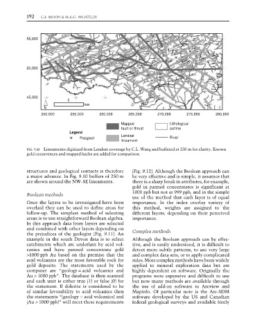
FIG. 9.10 Lineaments digitized from Landsat coverage by C.L. Wang and buffered at 250 m for clarity. Known
gold occurrences and mapped faults are added for comparison.
structures and geological contacts is therefore (Fig. 9.12). Although the Boolean approach can
a major advance. In Fig. 9.10 buffers of 250 m be very effective and is simple, it assumes that
are shown around the NW–SE lineaments. there is a sharp break in attributes, for example,
gold in panned concentrates is significant at
1001 ppb but not at 999 ppb, and in the simple
Boolean methods
use of the method that each layer is of equal
Once the layers to be investigated have been importance. In the index overlay variety of
overlaid they can be used to define areas for this method, weights are assigned to the
follow-up. The simplest method of selecting different layers, depending on their perceived
areas is to use straightforward Boolean algebra. importance.
In this approach data from layers are selected
and combined with other layers depending on
the prejudices of the geologist (Fig. 9.11). An Complex methods
example in the south Devon data is to select Although the Boolean approach can be effec-
catchments which are underlain by acid vol- tive, and is easily understood, it is difficult to
canics and have panned concentrate gold detect more subtle patterns, to use very large
>1000 ppb Au based on the premise that the and complex data sets, or to apply complicated
acid volcanics are the most favorable rock for rules. More complex methods have been widely
gold deposits. The statements used by the applied to mineral exploration data but are
computer are “geology = acid volcanics and highly dependent on software. Originally the
Au > 1000 ppb”. The database is then scanned programs were expensive and difficult to use
and each unit is either true (1) or false (0) for but now many methods are available through
the statement. If dolerite is considered to be the use of add-on software to Arcview and
of similar favorability to acid volcanics then Mapinfo. Of particular note is the Arc-SDM
the statements “(geology = acid volcanics) and software developed by the US and Canadian
(Au > 1000 ppb)” will meet these requirements federal geological surveys and available freely