
Page 142 - Origin and Prediction of Abnormal Formation Pressures
P. 142
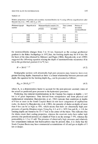
SMECTITE-ILLITE TRANSFORMATIONS                                       1 19

            TABLE 4-9
            Relative proportions  of primary and  secondary  montmorillonites  (in %) using  different magnifications  (after
            Buryakovsky et al.,  1995,  table 8, p.  215)

            Photomicrograph   Magnification   Montmorillonite content  (%)   Total content   Portion of
            number                    primary    secondary   ( % )       secondary
                                                                         montmorillonite
                                                                         (%)
            1             3000        14.5       7.1         21.6        32.9
            2             1000        13.5       6.5         20.0        32.5
            4             3000        10.5       5.4         15.9        34.0
            5             1000        14.3       5.2         19.5       26.7


            for  montmorillonite  changes  from  3  to  16  km.  Inasmuch  as  the  average  geothermal
            gradient  in  the  Baku  Archipelago  is  16~   the  limiting  depth  may  be  8-9  kin.  On
            the basis  of the data obtained by  Khitarov  and Pugin  (1966),  Buryakovsky  et al.  (1995)
            suggested the following  equation relating the depth  of montmorillonite  occurrence H  in
            km to the geothermal gradient G in ~

                 H  -  261G -123                                                (4-2)


               Stratigraphic  sections  with  abnormally high  pore  pressures  may, however,  have  even
            greater limiting  depths.  Inasmuch  as there is  a linear relationship  between  pressure  and
            depth,  the equation for the limiting depth  Hlim, can be presented  as follows"

                 nlim-  261KaG  -123                                            (4-3)

            where  Ka  is  a  dimensionless  factor  to  account  for  the  pore-pressure  anomaly  (ratio  of
            the actual (or predicted) pore pressure to the hydrostatic pressure).
               Predicting  clay-mineral  transformations  in  the  Caspian  Sea  region  at  depths  >  6.5
            km  is  of  great  importance.  Data  derived  from  extrapolation  and  from  physical  and
            mathematical  simulation  (Buryakovsky  et  al.,  1982)  indicate  that  conditions  at  depths
            of  9  km  or  more  in  the  South  Caspian  Basin  do  not  favor  catagenesis  of  argillaceous
            rocks.  As  shown by Buryakovsky  et al.  (1982),  the porosity  of shales  at depths  of more
            than  9  km  can  be  as  high  as  10%,  which  means  that  there  are  abnormally  high  pore
            pressures  of gravity-filtration origin.  Using Eq. 4-3,  at G  --  16~   and  Ka  =  1.8, the
            limiting depths  are found  to be  15-17  km in the center of the basin.  This  indicates  that
            the  shales  retain  their  sealing  properties,  whereas  the  reservoir  rocks  have  rather  high
            porosity  (the predicted porosity  at a depth of 9 km is on the average 7-9%,  whereas  the
            permeability is  1.5 to  11  mD.  The presence  of abnormally high pressures  and relatively
            low  temperatures  indicate  that  hydrocarbons  may  be  present;  thus,  it  is  likely  that  the
            South  Caspian  Basin may have commercial  accumulations  of oil and  gas  at depths  of 9
            km or deeper.