
Page 170 - Reservoir Geomechanics
P. 170
153 Faults and fractures at depth
A
A
B
D
Pt. Arguello
B
C
C
Santa Barbara Channel
Earthquake N D
magnitude:
< 2
2-4
4-6
50 km
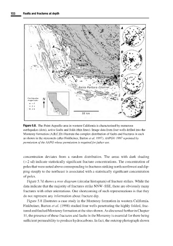
Figure 5.8. The Point Arguello area in western California is characterized by numerous
earthquakes (dots), active faults and folds (thin lines). Image data from four wells drilled into the
Monterey formation (A,B,C,D) illustrate the complex distribution of faults and fractures in each
as shown in the stereonets (after Finkbeiner, Barton et al. 1997). AAPG C 1997 reprinted by
permission of the AAPG whose permission is required for futher use.
concentration deviates from a random distribution. The areas with dark shading
(>2 sd) indicate statistically significant fracture concentrations. The concentration of
poles that were noted above corresponding to fractures striking north northwest and dip-
ping steeply to the northeast is associated with a statistically significant concentration
of poles.
Figure 5.7d shows a rose diagram (circular histogram) of fracture strikes. While the
data indicate that the majority of fractures strike NNW–SSE, there are obviously many
fractures with other orientations. One shortcoming of such representations is that they
do not represent any information about fracture dip.
Figure 5.8 illustrates a case study in the Monterey formation in western California.
Finkbeiner, Barton et al. (1998) studied four wells penetrating the highly folded, frac-
tured and faulted Monterey formation at the sites shown. As discussed further in Chapter
11, the presence of these fractures and faults in the Monterey is essential for there being
sufficient permeability to produce hydrocarbons. In fact, the outcrop photograph shown