
Page 311 - Soil and water contamination, 2nd edition
P. 311
298 Soil and Water Contamination
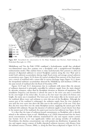
Zn (mg kg )
-1
< 125
125- 250
250- 500
500-1 000
>1 000 6642 6642 6642
Figure 16.9 Interpolated zinc concentrations for the Meuse floodplain near Meerssen, South Limburg, the
Netherlands (Burrough et al., 1996).
Middelkoop and Van der Perk (1998) combined a hydrodynamic model that calculated
two-dimensional water flow patterns over a floodplain with a straightforward floodplain
sedimentation model. This enabled them to relate hydrodynamic flow patterns to observed
amounts of deposited sediment in several floodplain sections along the river Waal and to
model both sediment accumulation during single flood events and average annual sediment
accumulation rates. Figure 16.10 shows the typical calculated flow patterns of the flood water
over a stretch of washland with a minor dike at various discharge stages; Figure 16.11 shows
the interpolated sediment accumulation observed by Middelkoop and Asselman (1998) on
the same stretch of washland after the flood of December 1993.
Figures 16.10 and 16.11 demonstrate that in washlands with minor dikes the amount
of sediment deposited is principally controlled by sediment supply from the main channel
by advective transport, rather than by floodplain elevation or duration of inundation. The
inundation frequency and duration is almost the same in the entire area and is controlled
by the crest height of the minor dike. As soon as the river water rises above the lowest crest
height, the entire area is inundated. The lower part of the minor dike in the western part of
the washland allows water and sediment to enter this part of the floodplain. Although the
eastern part of the washland is submerged, the sediment supply from the river channel is
zero until the river water rises above the dike crest in the eastern part of the area. Only then
does the river water flow over the entire floodplain section, supplying the eastern part of the
washland with sediment. Because the duration of sediment supply is much shorter here than
in the western part of the washland, the eastern part receives less sediment (see Figure 16.11).
It is clear that the input of sediment-bound contaminants on floodplain soils is directly
related to the sediment input to soil. Middelkoop et al. (2003) demonstrated that the heavy
metal concentrations in fresh sediment standardised for clay and organic matter content
(see Section 16.2) do not vary significantly within and among stretches of washlands .
Nevertheless, the absolute concentrations vary with particle size distribution. In general, the
clay and organic matter content of freshly deposited sediment increases with distance from
the sediment source (Thonon, 2006), i.e. along the flow line s as depicted in Figure 16.10. As
10/1/2013 6:45:32 PM
Soil and Water.indd 310 10/1/2013 6:45:32 PM
Soil and Water.indd 310