
Page 329 - Soil and water contamination, 2nd edition
P. 329
316 Soil and Water Contamination
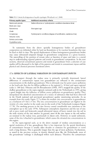
Table 17.1 Criteria for designation of aquifer typologies (Wendland et al., 2008).
Primary aquifer types Additional secondary criteria
Sands and gravels Saline influence or hydrodynamic conditions (residence time)
Marls and clays
Sandstones Geological age
Chalk
Limestones Hydrodynamic conditions (degree of karstification, residence time)
Volcanic rocks
Schists and shales
Crystalline rocks
To summarise from the above: spatially homogeneous bodies of groundwater
composition are delimited either by land use boundaries or by reaction boundaries that may
be fixed or shift in time. The spatial displacement of these homogeneous groundwater bodies
may cause substantial temporal changes in groundwater composition at a given location.
The unravelling of the position of stream tube s as function of space and time is a crucial
step in understanding regional patterns and trends in groundwater composition. In the next
sections, observed contaminant patterns and trends in groundwater from a selection of case
studies will be discussed in the light of the patterns and trends in contaminant inputs and the
physical and chemical processes mentioned above.
17.4 EFFECTS OF LATERAL VARIATION IN CONTAMINANT INPUTS
As the transport through the vadose zone is primarily vertically downward, lateral
differences in contaminant inputs into groundwater are reflected in the contaminant
concentrations in the shallow groundwater. This is obviously true for point source pollution
at the local scale, but also for diffuse pollution at the regional (> 10 km) and supra-regional
scales (> 100 km). Pebesma and De Kwaadsteniet (1994, 1997) mapped the quality of the
shallow groundwater at the supra-regional, national scale in the Netherlands in 1991, giving
a good insight into the influence of diffuse source pollution on groundwater quality. They
interpolated the dissolved concentrations of a variety of substances that had been observed
in the Dutch national and provincial groundwater quality monitoring networks. As an
example from this study, Figure 17.7a shows the median zinc concentration in groundwater
at a resolution of 4 km × 4 km. The zinc concentrations in groundwater are highest in the
vicinity of a zinc smelter in the sandy area in the south of the Netherlands (compare Figure
17.7b). The smelting process in the zinc factory caused considerable zinc emissions to the
atmosphere up to the early 1970s. Subsequent atmospheric deposition and the use of zinc
ash to pave roads and farmyards caused substantial inputs of heavy metals into the soil in
the wide vicinity of the zinc smelter. In general, most of the zinc inputs at the soil surface
are retained in the vadose zone, particularly in clayey soils. However, in sandy sediments,
some of the zinc is leached to groundwater, which causes the elevated zinc concentrations in
this region.
At the supra-regional scale , as in the above example of median concentrations at a
spatial resolution of 4 km, groundwater flow is less important for the spatial distribution
of contaminants because it usually takes decades to centuries for groundwater to travel
such a long distance. This is generally longer than the age of most pollution. Furthermore,
as noted in the previous section, in densely drained areas like the Netherlands, most of
the groundwater recharge is discharged within such distance. Therefore the contaminant
10/1/2013 6:47:03 PM
Soil and Water.indd 328
Soil and Water.indd 328 10/1/2013 6:47:03 PM