
Page 54 - The Petroleum System From Source to Trap
P. 54
46 Smith
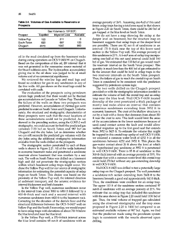
Table 2.4. Volumes of Gas Available to Reservoirs or average porosity of 26%. Assuming one-half of this sand
Prospects forms onlap traps having a total area equal to that shown
in Figure 2.20 on South Teton, there could be 240 bcf of
Gas Volumes (x 1 Q9 SCF) gas trapped at the blue level on South Teton.
Prospect Expelled Migration Loss Available We do not have a map showing the onlap at the
Yellow Pup 150 211 0 deeper level on basement, but the structure map on
South Teton 820 687 1 3 3 basement suggests that onlap traps at the deeper level
Chugach 2070 1 0 87 983 are possible. There are 82 net-ft of sandstone in an
interval 170 ft thick near the top of this lower sand
section in the Yellow Pup well. The average porosity of
oil in the mud circulated up from the basement rocks this sandstone is 21%. A 6-mi2 area of onlap trap incorpo
during coring operations on OC5-Y -0430 #1 on Chugach. rating one-half of this net sand interval could hold 160
Based on the composition of this oil, Elf inferred that it bcf of gas. We estimated that 133 bcf of gas would reach
was not generated in the nonmarine source material of the reservoir interval on the South Teton prospect. This
the Stuart subbasin area. The hydrocarbon accumulation quantity is much less than the 400 bcf of gas estimated to
giving rise to the oil show was judged to be of small be the amount that could be held in onlap traps in the
volume and of no commercial significance. two reservoir intervals on the South Teton prospect.
We reviewed the wire line logs and mud logs and Thus, the failure of gas to reach the crestal trap on South
found no evidence for gas in any sandstones in any of Teton is considered to be consistent with the prediction
the five wells. All gas shows on the mud logs could be suggested by petroleum system logic.
correlated with coals. The two wells drilled on the Chugach prospect
The evaluation of the prospects using petroleum provided us with the stratigraphic information needed to
system logic predicted that there would not be thermal estimate the volume of both the crestal trap and an onlap
gas accumulations on Cascade or Yellow Pup. Therefore, trap near the blue level. Well OCS-Y-0430 located
the failure of the wells on these two prospects was downdip of the crest penetrated a thick package of
predicted. However, accumulations of thermal gas were mostly seal rocks above an interval that contains
predicted to exist on South Teton and Chugach. Unfortu n u merous sandstones extending from 3952 ft to
nately, the structural and stratigraphic characteristics of economic basement. The crest of the shallow structure is
these prospects were such that the exact locations of cut by a fault with a throw that decreases from about 350
these accumulations could not be predicted. As we ft near the crest to zero. This fault would limit the areas
showed in the preceding section, using the COST-2 well of the accumulations in the lower sandstones because of
stratigraphy, we could account for both the predicted gas sand-sand contact across the fault and would allow
volumes (133 bcf on South Teton and 987 bcf on vertical migration up to the first good seal that extends
Chugach) and the dry holes. Let us determine whether from 3952 to 3625 ft. To estimate the volume that might
we can still reconcile the predicted gas volumes with the be trapped in this crestal trap updip of well ocs-Y -0430,
dry holes using the additional stratigraphic information we assumed a common water level of 4252 ft in all the
available from the wells drilled on the prospects. sandstones between 4252 and 3952 ft. This places the
The stratigraphic section penetrated by each of these gas-water contact about 20 ft above the level at which
wells is shown in Figure 2.21. All of the wells bottomed the hypothesized pay sandstone at 3952 ft is penetrated
in economic basement rocks and penetrated a sandstone in well OCS-Y-0430. There is 85 ft of sandstone in this
reservoir above basement that was overlain by a seal 300-ft-thick interval with an average porosity of 35%. We
rock The well on South Teton was drilled on a basement estimate that with a common water level this crestal trap
high and did not penetrate the stratigraphic section could hold 270 bcf without any gas extending downdip
within which basement onlap traps might occur. We to well OC5-Y-0430.
chose the Yellow Pup well for our source of stratigraphic well ocs-y -0425 was drilled to test a potentially large
information for estimating the potential capacity of onlap onlap trap on the Chugach prospect. The well penetrated
traps on South Teton. This choice was based on the a sandstone-rich section extending from 5608 ft to the
proximity of the Yellow Pup well, the inferred direction basement beneath a good seal approximately 140ft thick.
of sediment transport, and the seismic evidence for Thus, the conditions were excellent for an onlap trap.
interval thicknesses and bed character. The upper 113 ft of the sandstone section contained 97
In the Yellow Pup well, numerous sandstones occur net-ft of sandstone with an average porosity of 21%. We
in the interval from about 5000 to 6000 ft followed by a estimate that an onlap trap that included this sandstone
400-ft-thick seal rock and a second interval with
numerous sandstones from 6420 ft to the basement rock with the area shown in Figure 2.20 could hold 1130 bcf of
Correcting for the elevation of the derrick floor and the gas. Thus, the total volume of trapped gas calculated
structural difference between the OCS-Y -0407 well on using the observed stratigraphy and the trap areas
Yellow Pup and the South Teton onlap, we would expect proposed in Figure 2.20 is 1400 bcf compared to an
to have onlap traps with elevations of about 700 ft below estimated available volume of 987 bcf. Again, we find
the blue level and near the blue level. that the prediction made using the petroleum system
In the Yellow Pup well, a 370-ft-thick interval across logic is consistent with the results observed upon
the blue level contains 68 net-ft of sandstone with an drilling.