
Page 223 - Trenchless Technology Piping Installation and Inspection
P. 223
Pr oject Considerations for Horizontal Dir ectional Drilling 187
150 ft
Tools/equipment/spare parts
Crane
Drill pipe
100 ft Mud pump
Rig ramp Entry point
Fluid system & tank
Power unit/control cab
Bentonite storage
Workspace limits
(a)
150 ft
Workspace limits
Tools &
spare parts Pipe handling
equipment 50 ft
100 ft
Exit point Prefabricated pull section
supported on roller stands
Fluid system & Mud pump
tank (optional) (optional)
(b)
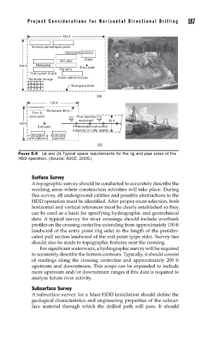
FIGURE 5.4 (a) and (b) Typical space requirements for the rig and pipe sides of the
HDD operation. (Source: ASCE, 2005.)
Surface Survey
A topographic survey should be conducted to accurately describe the
working areas where construction activities will take place. During
this survey, all underground utilities and possible obstructions to the
HDD operation must be identified. After proper route selection, both
horizontal and vertical references must be clearly established so they
can be used as a basis for specifying hydrographic and geotechnical
data. A typical survey for river crossings should include overbank
profiles on the crossing centerline extending from approximately 150 ft
landward of the entry point (rig side) to the length of the prefabri-
cated pull section landward of the exit point (pipe side). Survey ties
should also be made to topographic features near the crossing.
For significant waterways, a hydrographic survey will be required
to accurately describe the bottom contours. Typically, it should consist
of readings along the crossing centerline and approximately 200 ft
upstream and downstream. This scope can be expanded to include
more upstream and/or downstream ranges if this data is required to
analyze future river activity.
Subsurface Survey
A subsurface survey for a Maxi-HDD installation should define the
geological characteristics and engineering properties of the subsur-
face material through which the drilled path will pass. It should