
Page 117 - Acquisition and Processing of Marine Seismic Data
P. 117
108 2. MARINE SEISMIC DATA ACQUISITION
Since the nodes can be operated in surveys in periods to observe the changes in the reservoir
congested areas with obstacles such as produc- with time due to the oil or gas production. The
tion platforms and ROVs can precisely reposi- elapsed time between the base survey and sub-
tion the devices to their previous locations for sequent surveys, which is actually considered
each repeated survey, autonomous nodes are the fourth dimension, is typically a few months
successfully used for 4D reservoir monitoring, for permanent OBC installations to a few years
which requires a high level of repeatability. for conventional 3D towed streamer acquisition.
Acquisition by OBNs provides very ample fold The primary purpose is to obtain the differences
distributions around the platforms and provides between consecutively recorded data, which
better subsurface images as compared to towed indicates the variations in pressure, fluid con-
streamer NAZ seismic data, especially beneath tent or saturation distributions within the reser-
the complex geological structures such as salt voir due to the production, away from the well
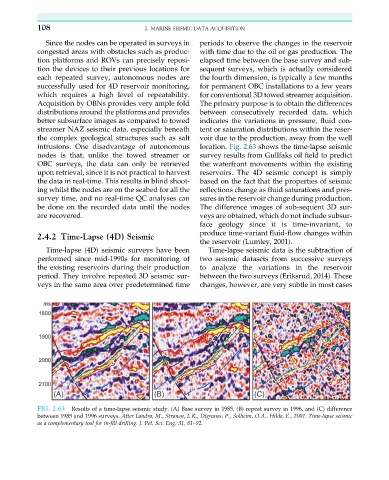
intrusions. One disadvantage of autonomous location. Fig. 2.63 shows the time-lapse seismic
nodes is that, unlike the towed streamer or survey results from Gullfaks oil field to predict
OBC surveys, the data can only be retrieved the waterfront movements within the existing
upon retrieval, since it is not practical to harvest reservoirs. The 4D seismic concept is simply
the data in real-time. This results in blind shoot- based on the fact that the properties of seismic
ing whilst the nodes are on the seabed for all the reflections change as fluid saturations and pres-
survey time, and no real-time QC analyses can sures in the reservoir change during production.
be done on the recorded data until the nodes The difference images of sub-sequent 3D sur-
are recovered. veys are obtained, which do not include subsur-
face geology since it is time-invariant, to
produce time-variant fluid-flow changes within
2.4.2 Time-Lapse (4D) Seismic
the reservoir (Lumley, 2001).
Time-lapse (4D) seismic surveys have been Time-lapse seismic data is the subtraction of
performed since mid-1990s for monitoring of two seismic datasets from successive surveys
the existing reservoirs during their production to analyze the variations in the reservoir
period. They involve repeated 3D seismic sur- between the two surveys (Eriksrud, 2014). These
veys in the same area over predetermined time changes, however, are very subtle in most cases
FIG. 2.63 Results of a time-lapse seismic study. (A) Base survey in 1985, (B) repeat survey in 1996, and (C) difference
between 1985 and 1996 surveys. After Landrø, M., Strønen, L.K., Digranes, P., Solheim, O.A., Hilde, E., 2001. Time-lapse seismic
as a complementary tool for in-fill drilling. J. Pet. Sci. Eng. 31, 81–92.