Page 294 - Digital Analysis of Remotely Sensed Imagery
P. 294

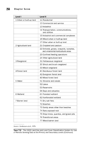
256    Cha pte r  Se v e n


                 Level I               Level II
                 1 Urban or built-up land  11 Residential
                                       12 Commercial and service
                                       13 Industrial
                                       14 Transportation, communications,
                                            and utilities
                                       15 Industrial and commercial complexes
                                       16 Mixed urban or built-up land
                                       17 Other urban or built-up land
                 2 Agricultural land   21 Cropland and pasture
                                       22 Orchards, groves, vineyards, nurseries,
                                            and ornamental horticultural areas
                                       23 Confined feeding operations
                                       24 Other agricultural land
                 3 Rangeland           31 Herbaceous rangeland
                                       32 Shrub and brush rangeland
                                       33 Mixed rangeland
                 4 Forest land         41 Deciduous forest land
                                       42 Evergreen forest land
                                       43 Mixed forest land
                 5 Water               51 Streams and canals
                                       52 Lakes
                                       53 Reservoirs
                                       54 Bays and estuaries
                 6 Wetland             61 Forested wetland
                                       62 Nonforested wetland
                 7 Barren land         71 Dry salt flats
                                       72 Beaches
                                       73 Sandy areas other than beaches
                                       74 Bare exposed rock
                                       75 Strip mines, quarries, and gravel pits
                                       76 Transitional areas
                                       77 Mixed barren land


               Source: Anderson et al., 1976.
               TABLE 7.2  The USGS Land Use and Land Cover Classification System for Use
               of Remote Sensing Data at the Primary and Secondary Levels (Continued)
   289   290   291   292   293   294   295   296   297   298   299