
Page 247 - Earth's Climate Past and Future
P. 247
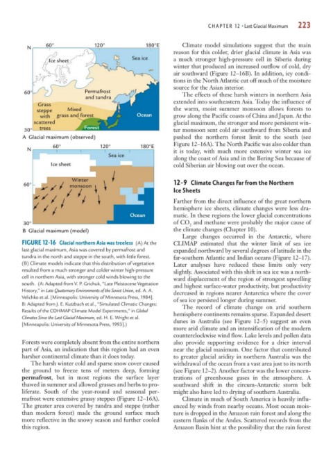
CHAPTER 12 • Last Glacial Maximum  223


                60°              120°             180°E        Climate model simulations suggest that the main
          N
                                                            reason for this colder, drier glacial climate in Asia was
                                              Sea ice       a much stronger high-pressure cell in Siberia during
                  Ice sheet
                                                            winter that produced an increased outflow of cold, dry
                                                            air southward (Figure 12–16B). In addition, icy condi-
                                                            tions in the North Atlantic cut off much of the moisture
                                                            source for the Asian interior.
         60°                  Permafrost                       The effects of these harsh winters in northern Asia
                              and tundra
                                                            extended into southeastern Asia. Today the influence of
              Grass
             steppe     Mixed                               the warm, moist summer monsoon allows forests to
               with  grass and forest          Ocean        grow along the Pacific coasts of China and Japan. At the
            scattered                                       glacial maximum, the stronger and more persistent win-
         30°  trees           Forest                        ter monsoon sent cold air southward from Siberia and
         A  Glacial maximum (observed)                      pushed the northern forest limit to the south (see
                   60°             120°          180°E      Figure 12–16A). The North Pacific was also colder than
          N                                                 it is today, with much more extensive winter sea ice
                                      Sea ice
                                                            along the coast of Asia and in the Bering Sea because of
                  Ice sheet                                 cold Siberian air blowing out over the ocean.


                         Winter
         60°             monsoon                            12-9 Climate Changes Far from the Northern
                                                            Ice Sheets
                                                            Farther from the direct influence of the great northern
                                                            hemisphere ice sheets, climate changes were less dra-
                                             Ocean          matic. In these regions the lower glacial concentrations
         30°                                                of CO and methane were probably the major cause of
                                                                 2
         B  Glacial maximum (model)                         the climate changes (Chapter 10).
                                                               Large changes occurred in the Antarctic, where
        FIGURE 12-16 Glacial northern Asia was treeless (A) At the  CLIMAP estimated that the winter limit of sea ice
        last glacial maximum, Asia was covered by permafrost and  expanded northward by several degrees of latitude in the
        tundra in the north and steppe in the south, with little forest.   far-southern Atlantic and Indian oceans (Figure 12–17).
        (B) Climate models indicate that this distribution of vegetation  Later analyses have reduced these limits only very
        resulted from a much stronger and colder winter high-pressure  slightly. Associated with this shift in sea ice was a north-
        cell in northern Asia, with stronger cold winds blowing to the  ward displacement of the region of strongest upwelling
        south. (A: Adapted from V. P. Grichuk, “Late Pleistocene Vegetation  and highest surface-water productivity, but productivity
        History,” in Late Quaternary Environments of the Soviet Union, ed. A. A.  decreased in regions nearer Antarctica where the cover
        Velichko et al. [Minneapolis: University of Minnesota Press, 1984].   of sea ice persisted longer during summer.
        B: Adapted from J. E. Kutzbach et al., “Simulated Climatic Changes:  The record of climate change on arid southern
        Results of the COHMAP Climate Model Experiments,” in Global  hemisphere continents remains sparse. Expanded desert
        Climates Since the Last Glacial Maximum, ed. H. E. Wright et al.  dunes in Australia (see Figure 12–5) suggest an even
        [Minneapolis: University of Minnesota Press, 1993].)
                                                            more arid climate and an intensification of the modern
                                                            counterclockwise wind flow. Lake levels and pollen data
        Forests were completely absent from the entire northern  also provide supporting evidence for a drier interval
        part of Asia, an indication that this region had an even  near the glacial maximum. One factor that contributed
        harsher continental climate than it does today.     to greater glacial aridity in northern Australia was the
           The harsh winter cold and sparse snow cover caused  withdrawal of the ocean from a vast area just to its north
        the ground to freeze tens of meters deep, forming   (see Figure 12–2). Another factor was the lower concen-
        permafrost, but in most regions the surface layer   trations of greenhouse gases in the atmosphere. A
        thawed in summer and allowed grasses and herbs to pro-  southward shift in the circum-Antarctic storm belt
        liferate. South of the year-round and seasonal per-  might also have led to drying of southern Australia.
        mafrost were extensive grassy steppes (Figure 12–16A).  Climate in much of South America is heavily influ-
        The greater area covered by tundra and steppe (rather  enced by winds from nearby oceans. Most ocean mois-
        than modern forest) made the ground surface much    ture is dropped in the Amazon rain forest and along the
        more reflective in the snowy season and further cooled  eastern flanks of the Andes. Scattered records from the
        this region.                                        Amazon Basin hint at the possibility that the rain forest