
Page 244 - Earth's Climate Past and Future
P. 244
220 PART IV • Deglacial Climate Change
off, and around the ice sheets in winter. Cold air flow-
ing eastward along the northern flank of the North 0
American ice sheet as part of this circulation blew
southeastward over the western North Atlantic, chilling
the ocean surface. A narrow layer of cold winds blew 5
westward across the northern United States, reversing
the west-to-east wind flow that dominates that region
today. In Alaska, the clockwise pattern produced a
south-to-north wind flow during the glacial maximum
that may have prevented climate in the ice-free Alaskan 10
interior from becoming even harsher than it is today. 15
A similar clockwise spiral of winds over the Scandi- A Sea surface
North Atlantic Drift
navian ice sheet brought cold, dry air southward into temperature 20
Europe (see Figure 12–11B). In addition, a strong (°C)
upper-level jet stream crossed the Atlantic Ocean along
latitudes between 45° and 50°N and entered Europe
south of the ice sheet.
200
12-8 Climate Changes Near the Northern Ice Sheets
The most dramatic changes in climate at the glacial
maximum were those in regions closest to and most
directly influenced by the ice sheets. Most of the cli-
mate changes simulated by the models are consistent 300
with independent geologic evidence.
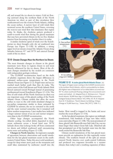
The CLIMAP reconstruction based on the shells B Ice rafting
of planktic organisms shows the largest differences in (mg/cm 2 /1000yr)
estimated surface-ocean temperatures in the North
Atlantic Ocean (see Figure 12–2). Frigid water and sea ice FIGURE 12-12 A cooler glacial North Atlantic Ocean (A)
reached much farther south than they do today. The The region of largest ocean cooling in the CLIMAP reconstruction
warm waters of the Gulf Stream and North Atlantic Drift is the northern North Atlantic, which is surrounded by ice sheets.
flowed eastward toward Portugal instead of penetrating (B) Highest rates of deposition of ice-rafted debris occurred near
northeastward toward Scandinavia (Figure 12–12A). The 50° N, where southward-floating icebergs first encountered warm
flow of cold winds off the North American ice sheet was waters and melted. (A: Adapted from A. McIntyre et al., “Glacial
one important cause of this glacial cooling of the North North Atlantic 18,000 Years Ago: A CLIMAP Reconstruction,”
Atlantic Ocean. Climate models that allow the ocean Geological Society of America Memoir 145 [1976]: 43–76. B: Adapted
surface to react to the cold winds simulated changes in from W. F. Ruddiman, “North Atlantic Ice Rafting: A Major
sea-surface temperature similar to those estimated by Change at 75,000 Years b.p.,” Science 196 [1977]: 1208–11.)
CLIMAP. In summer, the sea ice retreated to the north
and the water warmed somewhat, but it remained well
below modern temperatures. Later studies have indicated basins. Most runoff is trapped in the basins and never
a larger summer retreat of sea ice and warmer tempera- reaches the ocean (Figure 12–13A).
tures than in the CLIMAP reconstruction. At the last glacial maximum, this region was strikingly
Other large changes accompanied the North transformed, with hundreds of large new lakes where
Atlantic cooling. Ice-rafted debris deposited in deep- none exist today (Figure 12–13B). The most prominent of
ocean sediments across a broad band near 50°N these, glacial Lake Bonneville near Salt Lake City, was ten
latitude shows that icebergs broke off from continental times larger than today’s Great Salt Lake. Dissolved salt
ice sheets and drifted southward until encountering that precipitated out of the brackish water into the lake
warm water and melting (Figure 12–12B). muds created the Bonneville Salt Flats.
Changes in North America An impressive example Climate model simulations of the last glacial maxi-
of agreement between observations and model simula- mum provide an explanation for this regionally wetter
tions for the last glacial maximum occurs in the south- climate. The southern branch of the split jet stream
western United States. Today this area is arid semidesert, entered North America over south-central California
except for deep winter snow pack on the mountains and and produced two responses favorable to a moister
small lakes maintained by meltwater runoff into the climate than today’s and a resulting expansion of lakes: