
Page 245 - Earth's Climate Past and Future
P. 245
CHAPTER 12 • Last Glacial Maximum 221
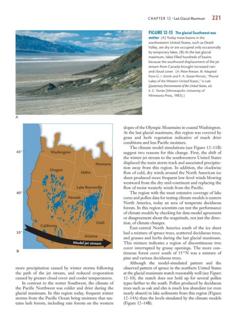
FIGURE 12-13 The glacial Southwest was
wetter (A) Today most basins in the
southwestern United States, such as Death
Valley, are dry or are occupied only occasionally
by temporary lakes. (B) At the last glacial
maximum, lakes filled hundreds of basins
because the southward displacement of the jet
stream from Canada brought increased rain
and cloud cover. (A: Peter Kresan. B: Adapted
from G. I. Smith and F. A. Street-Perrott, “Pluvial
Lakes of the Western United States,” in Late
Quaternary Environments of the United States, ed.
S. C. Porter [Minneapolis: University of
Minnesota Press, 1983].)
A
slopes of the Olympic Mountains in coastal Washington.
At the last glacial maximum, this region was covered by
grass and herb vegetation indicative of much drier
conditions and less Pacific moisture.
The climate model simulations (see Figure 12–11B)
45° Washington suggest two reasons for this change. First, the shift of
the winter jet stream to the southwestern United States
displaced the main storm track and associated precipita-
Montana
tion away from this region. In addition, the clockwise
Oregon
Idaho flow of cold, dry winds around the North American ice
sheet produced more frequent low-level winds blowing
westward from the dry mid-continent and replacing the
Lake Bonneville flow of moist westerly winds from the Pacific.
40° The region with the most extensive coverage of lake
Nevada cores and pollen data for testing climate models is eastern
North America, today an area of temperate deciduous
forests. In this region scientists can test the performance
of climate models by checking for data-model agreement
or disagreement about the magnitude, not just the direc-
Utah tion, of climate changes.
California
East-central North America south of the ice sheet
35° had a mixture of spruce trees, scattered deciduous trees,
Arizona
and grasses and herbs during the last glacial maximum.
Model jet stream This mixture indicates a region of discontinuous tree
cover interrupted by grassy openings. The more con-
B
tinuous forest cover south of 35°N was a mixture of
pine and various deciduous trees.
Although the model-simulated pattern and the
more precipitation caused by winter storms following observed pattern of spruce in the northern United States
the path of the jet stream, and reduced evaporation at the glacial maximum match reasonably well (see Figure
caused by greater cloud cover and cooler temperatures. 12–10), the match does not hold up for several pollen
In contrast to the wetter Southwest, the climate of types farther to the south. Pollen produced by deciduous
the Pacific Northwest was colder and drier during the trees such as oak and elm is much less abundant (or even
glacial maximum. In this region today, frequent winter nearly absent) in lake sediments from this region (Figure
storms from the Pacific Ocean bring moisture that sus- 12–14A) than the levels simulated by the climate models
tains lush forests, including rain forests on the western (Figure 12–14B).