
Page 292 - Geochemical Anomaly and Mineral Prospectivity Mapping in GIS
P. 292
Data-Driven Modeling of Mineral Prospectivity 295
whole is significant). The smaller the value of Wilks’ lambda, the more statistically
significant is a discriminant model. Second, if a discriminant model as a whole is
statistically significant, then the individual predictor variables are assessed with an F-test
(Wilks’ lambda) to determine which of them contribute significantly to the discriminant
model (i.e., to determine which predictor variables have significantly different means
between groups). Predictor variables that do not contribute significantly to the
discrimination of the groups are excluded in the final discriminant model.
GIS-based spatial evidence representation for discriminant analysis
A scheme of spatial evidence representation of categorical predictor variables is
adopted here (Fig. 8-20) for the GIS-based application of LDA to the case study area so
that the results can be compared properly with the earlier results of the application of
data-driven EBFs in modeling of epithermal Au prospectivity in the case study area.
Carranza and Hale (2001b) and Carranza (2002) demonstrated this scheme of spatial
evidence representation for logistic regression modeling of mineral prospectivity in
certain case study areas, the results of which are comparable to the results of weights-of-
evidence modeling (Carranza and Hale, 2000; Carranza, 2002) and data-driven
evidential belief modeling (Carranza, 2002; Carranza and Hale, 2003) of mineral
prospectivity in the same case study areas.
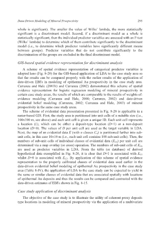
The scheme of evidential data presentation presented in Fig. 8-20 is applicable in a
raster-based GIS. First, the study area is partitioned into unit cells of a suitable size (i.e.,
100×100 m, see above) and each unit cell is given a unique ID. Each unit cell represents
a location (L), which can be either a deposit-type location (D=1) or a non-deposit
location (D=0). The values of D per unit cell are used as the target variable in LDA.
Next, the map of an evidential data E (with n classes C n) is partitioned further into sub-
unit cells, in this case 10×10 m (i.e., each unit cell contains 100 sub-unit cells). Then, the
numbers of sub-unit cells of individual classes of evidential data (E Cn) per unit cell are
determined via a map overlay (or cross) operation. The numbers of sub-unit cells of E Cn
are used as predictor variables in LDA. From the table (or database) of derived
hypothetical data exemplified in Fig. 8-20, it is clear that D=1 is associated with E C1
whilst D=0 is associated with E C2. By application of this scheme of spatial evidence
representation to the properly calibrated classes of evidential data used earlier in the
data-driven evidential belief modeling of epithermal Au prospectivity in the case study
area (Table 8-IV), the application of LDA to the case study can be expected to yield in
the same or similar classes of evidential data that are associated spatially with locations
of epithermal Au deposits and thus the results can be compared and contrasted with the
data-driven estimates of EBFs shown in Fig. 8-15.
Case study application of discriminant analysis
The objective of the case study is to illustrate the utility of coherent proxy deposit-
type locations in modeling of mineral prospectivity via the application of a multivariate