
Page 84 - Geochemical Anomaly and Mineral Prospectivity Mapping in GIS
P. 84
Exploratory Analysis of Geochemical Anomalies 83
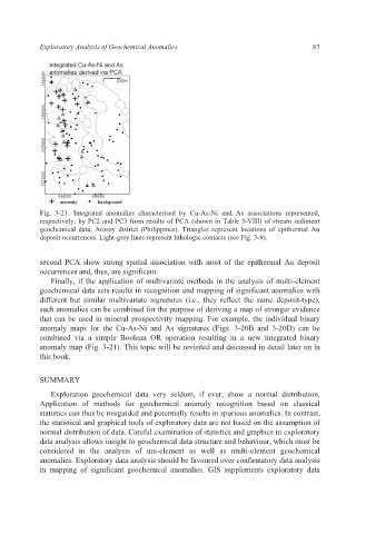
Fig. 3-21. Integrated anomalies characterised by Cu-As-Ni and As associations represented,
respectively, by PC2 and PC3 from results of PCA (shown in Table 3-VIII) of stream sediment
geochemical data, Aroroy district (Philippines). Triangles represent locations of epithermal Au
deposit occurrences. Light-grey lines represent lithologic contacts (see Fig. 3-9).
second PCA show strong spatial association with most of the epithermal Au deposit
occurrences and, thus, are significant.
Finally, if the application of multivariate methods in the analysis of multi-element
geochemical data sets results in recognition and mapping of significant anomalies with
different but similar multivariate signatures (i.e., they reflect the same deposit-type),
such anomalies can be combined for the purpose of deriving a map of stronger evidence
that can be used in mineral prospectivity mapping. For example, the individual binary
anomaly maps for the Cu-As-Ni and As signatures (Figs. 3-20B and 3-20D) can be
combined via a simple Boolean OR operation resulting in a new integrated binary
anomaly map (Fig. 3-21). This topic will be revisited and discussed in detail later on in
this book.
SUMMARY
Exploration geochemical data very seldom, if ever, show a normal distribution.
Application of methods for geochemical anomaly recognition based on classical
statistics can thus be misguided and potentially results in spurious anomalies. In contrast,
the statistical and graphical tools of exploratory data are not based on the assumption of
normal distribution of data. Careful examination of statistics and graphics in exploratory
data analysis allows insight to geochemical data structure and behaviour, which must be
considered in the analysis of uni-element as well as multi-element geochemical
anomalies. Exploratory data analysis should be favoured over confirmatory data analysis
in mapping of significant geochemical anomalies. GIS supplements exploratory data