
Page 204 - Geochemical Remote Sensing of The Sub-Surface
P. 204
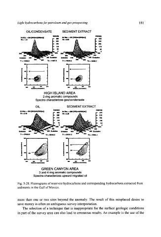
Light hydrocarbons for petroleum and gas prospecting                  181
                OIL/CONDENSATE       SEDIMENT EXTRACT
                                                        JmuwV
              lu..  ~s, i~o(e)mo(ot}l   ao  it p,~t..,a4 P~Yaol-)i
                                 ,.on  .=o..
             FU. ,.,o            S          j~         f~


              300  -  ~                            -300  IExciletlm
                             --
                              440
            En#ldon   400-  ~   3K)O F.xdMlion   EfflklMoll   400-  ~
             T1 -  12448.0   "r2  9 11067.9   TI  -- 19~3a.2   'r2 .. lllOeO.7
               6oo                     m           ,,,
             I


               200   '   *   *,,'      200   I   I   I   ,   ,
                mO   iJO0   404)   800   dO0   am   400   MO
                   r:mJim (mumms)             (nlm ometem)
                          HIGH  ISLAND  AREA
                          2-ring aromatic compounds
                     Spectra characterizes gas/condensate
                     OIL               SEDIMENT EXTRACT
              Ua. = ,~s I,lm~m)rJoo(uN   N  Max.. ~  (a7o(emyaao(~)l


                                     !:!


             T1,  a1743L4   o~o   200  T2..3a41i3.6   T!  -~3104.3   "r2,1644.1
               m      i                "            I


             !   -                               v

               I~   i   1   |   /    9   m
                   rJJa~   (n,,mmnn)
                         GREEN  CANYON  AREA
                       3 and 4 ring aromatic compounds
                    Spectra characterizes upward migrated oil

           Fig. 5-28.  Fluorograms of reservoir hydrocarbons and corresponding hydrocarbons  extracted from
           sediments in the Gulf of Mexico.


           more  than  one  or  two  sites  beyond  the  anomaly.  The  result  of this  misplaced  desire  to
           save  money  is often an ambiguous  survey interpretation.
              The  selection  of a technique  that  is  inappropriate  for the  surface  geologic  conditions
           in part of the  survey  area can also  lead to erroneous  results.  An  example  is the use  of the