
Page 281 - Hydrogeology Principles and Practice
P. 281
HYDC07 12/5/05 5:32 PM Page 264
264 Chapter Seven
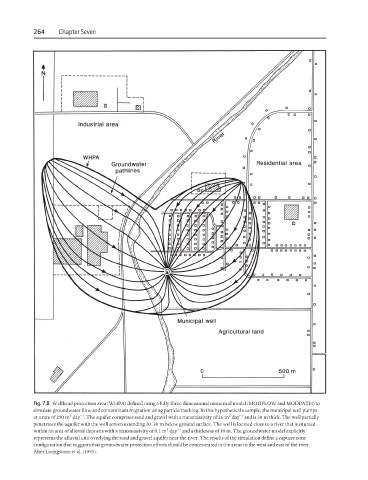
Fig. 7.8 Wellhead protection area (WHPA) defined using a fully three-dimensional numerical model (MODFLOW and MODPATH) to
simulate groundwater flow and contaminant migration using particle tracking. In this hypothetical example, the municipal well pumps
3
−1
2
−1
at a rate of 250 m day . The aquifer comprises sand and gravel with a transmissivity of 26 m day and is 30 m thick. The well partially
penetrates the aquifer with the well screen extending 20–30 m below ground surface. The well is located close to a river that is situated
2
−1
within an area of alluvial deposits with a transmissivity of 0.1 m day and a thickness of 10 m. The groundwater model explicitly
represents the alluvial unit overlying the sand and gravel aquifer near the river. The results of the simulation define a capture zone
configuration that suggests that groundwater protection efforts should be concentrated in the areas to the west and east of the river.
After Livingstone et al. (1995).