
Page 278 - Hydrogeology Principles and Practice
P. 278
HYDC07 12/5/05 5:32 PM Page 261
Groundwater pollution remediation and protection 261
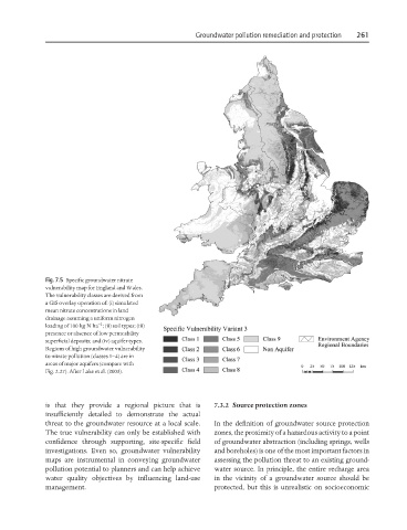
Fig. 7.5 Specific groundwater nitrate
vulnerability map for England and Wales.
The vulnerability classes are derived from
a GIS overlay operation of: (i) simulated
mean nitrate concentrations in land
drainage assuming a uniform nitrogen
−1
loading of 100 kg N ha ; (ii) soil types; (iii)
presence or absence of low permeability
superficial deposits; and (iv) aquifer types.
Regions of high groundwater vulnerability
to nitrate pollution (classes 1–4) are in
areas of major aquifers (compare with
Fig. 2.27). After Lake et al. (2003).
is that they provide a regional picture that is 7.3.2 Source protection zones
insufficiently detailed to demonstrate the actual
threat to the groundwater resource at a local scale. In the definition of groundwater source protection
The true vulnerability can only be established with zones, the proximity of a hazardous activity to a point
confidence through supporting, site-specific field of groundwater abstraction (including springs, wells
investigations. Even so, groundwater vulnerability and boreholes) is one of the most important factors in
maps are instrumental in conveying groundwater assessing the pollution threat to an existing ground-
pollution potential to planners and can help achieve water source. In principle, the entire recharge area
water quality objectives by influencing land-use in the vicinity of a groundwater source should be
management. protected, but this is unrealistic on socioeconomic