
Page 275 - Hydrogeology Principles and Practice
P. 275
HYDC07 12/5/05 5:32 PM Page 258
258 Chapter Seven
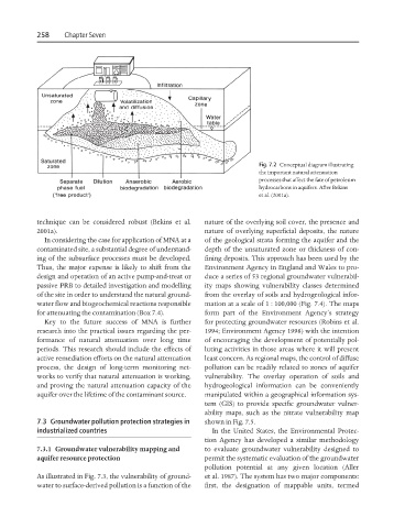
Fig. 7.2 Conceptual diagram illustrating
the important natural attenuation
processes that affect the fate of petroleum
hydrocarbons in aquifers. After Bekins
et al. (2001a).
technique can be considered robust (Bekins et al. nature of the overlying soil cover, the presence and
2001a). nature of overlying superficial deposits, the nature
In considering the case for application of MNA at a of the geological strata forming the aquifer and the
contaminated site, a substantial degree of understand- depth of the unsaturated zone or thickness of con-
ing of the subsurface processes must be developed. fining deposits. This approach has been used by the
Thus, the major expense is likely to shift from the Environment Agency in England and Wales to pro-
design and operation of an active pump-and-treat or duce a series of 53 regional groundwater vulnerabil-
passive PRB to detailed investigation and modelling ity maps showing vulnerability classes determined
of the site in order to understand the natural ground- from the overlay of soils and hydrogeological infor-
water flow and biogeochemical reactions responsible mation at a scale of 1 : 100,000 (Fig. 7.4). The maps
for attenuating the contamination (Box 7.4). form part of the Environment Agency’s strategy
Key to the future success of MNA is further for protecting groundwater resources (Robins et al.
research into the practical issues regarding the per- 1994; Environment Agency 1998) with the intention
formance of natural attenuation over long time of encouraging the development of potentially pol-
periods. This research should include the effects of luting activities in those areas where it will present
active remediation efforts on the natural attenuation least concern. As regional maps, the control of diffuse
process, the design of long-term monitoring net- pollution can be readily related to zones of aquifer
works to verify that natural attenuation is working, vulnerability. The overlay operation of soils and
and proving the natural attenuation capacity of the hydrogeological information can be conveniently
aquifer over the lifetime of the contaminant source. manipulated within a geographical information sys-
tem (GIS) to provide specific groundwater vulner-
ability maps, such as the nitrate vulnerability map
7.3 Groundwater pollution protection strategies in shown in Fig. 7.5.
industrialized countries In the United States, the Environmental Protec-
tion Agency has developed a similar methodology
7.3.1 Groundwater vulnerability mapping and to evaluate groundwater vulnerability designed to
aquifer resource protection permit the systematic evaluation of the groundwater
pollution potential at any given location (Aller
As illustrated in Fig. 7.3, the vulnerability of ground- et al. 1987). The system has two major components:
water to surface-derived pollution is a function of the first, the designation of mappable units, termed