
Page 225 - Integrated Wireless Propagation Models
P. 225
M i c r o c e l l P r e d i c t i o n M o d e l s 203
Cell site
I >= -65 dBm
> 85 dBm
> 75 dBm
> 85 dBm
> 95 dBm
> 1 0 5 dBm
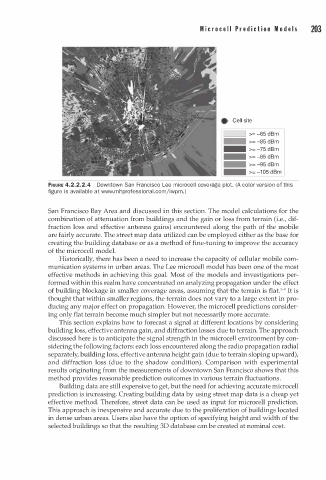
FIGURE 4.2.2.2.4 Downtown San Francisco Lee microcell coverage plot. (A color version of this
a
figure is av i l able at www.m h p rofessional.comjiwpm.)
San Francisco Bay Area and discussed in this section. The model calculations for the
combination of attenuation from buildings and the gain or loss from terrain (i.e., dif
fraction loss and effective antenna gains) encountered along the path of the mobile
are fairly accurate. The street map data utilized can be employed either as the base for
creating the building database or as a method of fine-tuning to improve the accuracy
of the microcell model.
Historically, there has been a need to increase the capacity of cellular mobile com
munication systems in urban areas. The Lee microcell model has been one of the most
effective methods in achieving this goal. Most of the models and investigations per
formed within this realm have concentrated on analyzing propagation under the effect
1
of building blockage in smaller coverage areas, assuming that the terrain is flat. -9 1t is
thought that within smaller regions, the terrain does not vary to a large extent in pro
ducing any major effect on propagation. However, the microcell predictions consider
ing only flat terrain become much simpler but not necessarily more accurate.
This section explains how to forecast a signal at different locations by considering
building loss, effective antenna gain, and diffraction losses due to terrain. The approach
discussed here is to anticipate the signal strength in the microcell environment by con
sidering the following factors: each loss encountered along the radio propagation radial
separately, building loss, effective antenna height gain (due to terrain sloping upward),
and diffraction loss (due to the shadow condition). Comparison with experimental
results originating from the measurements of downtown San Francisco shows that this
method provides reasonable prediction outcomes in various terrain fluctuations.
Building data are still expensive to get, but the need for achieving accurate microcell
prediction is increasing. Creating building data by using street map data is a cheap yet
effective method. Therefore, street data can be used as input for microcell prediction.
This approach is inexpensive and accurate due to the proliferation of buildings located
in dense urban areas. Users also have the option of specifying height and width of the
selected buildings so that the resulting 30 database can be created at nominal cost.