
Page 226 - Integrated Wireless Propagation Models
P. 226
204 C h a p t e r F o u r
This street data can be further utilized not only as a base for creating a building
database but also as a method of fine-tuning, which is necessary to improve the accu
racy of the microcell model. The ETAK data can also be employed as a base to build
building data with low granularity. Building data with fine granularity can then be
structured by combining ETAK data and street map data.
Figure 4.2.2.2.5 displays a sample of variation in terrain in the Los Angeles region.
These data are readily accessible via the Internet. As shown in Fig. 4.2.2.2.6, there is a
significant amount of terrain undulation within the region, and the terrain effect cannot
be ignored in many major urban cities.
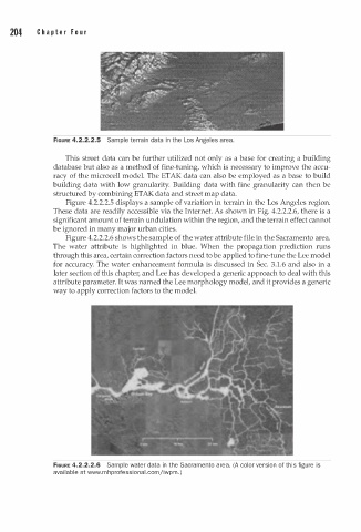
Figure 4.2.2.2.6 shows the sample of the water attribute file in the Sacramento area.
The water attribute is highlighted in blue. When the propagation prediction runs
through this area, certain correction factors need to be applied to fine-tune the Lee model
for accuracy. The water enhancement formula is discussed in Sec. 3.1.6 and also in a
later section of this chapter, and Lee has developed a generic approach to deal with this
attribute parameter. It was named the Lee morphology model, and it provides a generic
way to apply correction factors to the model.
FIGURE 4.2.2.2.6 Sample water data in the Sacramento area. (A color version of this figure is
av i lable at www.mhprofessional.comjiwpm. )
a