
Page 122 - Introduction to Mineral Exploration
P. 122
6: REMOTE SENSING 105
1 Landsat Multispectral Scanner (MSS); Active sensors
2 Landsat Thematic Mapper (TM) utilizes These sensors use their own source of energy.
additional wavelengths, and has superior spec- They emit energy and measure the intensity of
tral and spatial resolution compared with MSS energy reflected by a target. Some examples are
images; Radar (microwave) and Lasers (European Space
3 Advanced Spaceborne Thermal Emission and Agency 2004).
Reflection Radiometer (ASTER) on NASA’s
satellite Terra;
4 SPOT, a French commercial satellite with 6.2 THE LANDSAT SYSTEM
stereoscopic capabilities;
5 high resolution commercial satellites, such The first Landsat satellite, originally called
as Ikonos (Infoterra 2004), the first of the next Earth Resources Technology Satellite (ERTS),
generation of high spatial resolution satellites, was launched in July 1972. Seven satellites in
and QuickBird (Ball Aerospace & Technologies the series have been launched (Table 6.1).
Corp 2002); Landsat has been superseded by the Terra
6 Space Shuttle; satellite, hosting the ASTER sensors (Abrams
7 airborne scanning systems that have even & Hook 2002).
greater resolution and can look at more and Each satellite is solar powered and has a data
narrower wavebands. collecting system which transmits data to the
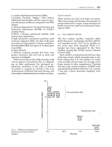
Different satellites collect different data with home station (Fig. 6.2). On Landsat 1 to 3 data
various degrees of resolution (Fig. 6.1) depend- were recorded on tape when out of range of the
ing on their application. For geological ap- home station for later transmission. Tracking
plications resolution of the order of meters and data relay system satellites (TDRSS) were
of Landsat is required in contrast to the tens operational from March 1984 (Fig. 6.2). Landsat
of kilometers of NOAA (National Oceanic and 7 has only a direct downlink capability with
Atmospheric Administration) weather satellites. recorders.
100
SPOT LANDSAT Sun synchronous orbits
Terra
Frequency of repetitive cover (days) 10 Aster Geostationary orbits
TM MSS
1
TIROS-N
METEOSAT
FIG. 6.1 Different resolution and
frequencies of some satellite 10 m 100 m 1km 10km
imagery. Pixel size