
Page 182 - Introduction to Mineral Exploration
P. 182
8: EXPLORATION GEOCHEMISTRY 165
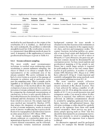
TABLE 8.4 Application of the main exploration geochemical methods.
Planning Drainage Lake Water Soil Deep Rock Vegetation Gas
scale sediments sediments overburden
Reconnaissance 1:10,000 to Common Glacial Arid Common Laterite Glacial Good outcrop Forests
1:100,000
Detailed 1:2500 to Common Common Forests Arid
1:10,000
Drilling >1:1000 Common
Common, commonly used. Other techniques useful in areas noted.
method to be used depends on the origin of the background contrast for trace metals is
overburden. If it is residual, i.e. derived from obtained in the fine fraction of the sediments as
the rock underneath, the problem is relatively this contains the majority of the organic mater-
straightforward but if the overburden is exotic, ial, clays, and iron and manganese oxides. The
i.e. transported, then different methods must be coarser fractions including pebbles are gener-
used. A summary of the application of various ally of more local origin and depleted in trace
geochemical techniques is given in Table 8.4. elements. Usually the size cut-off is taken at
80 mesh (<177 µm). However, the grain size giv-
ing best contrast should be determined by an
8.4.1 Stream sediment sampling
orientation survey. For base metal analysis and
The most widely used reconnaissance geochemical mapping a 0.5 kg sample is suf-
technique in residual areas undergoing active ficient but a much larger sample is required
weathering is stream sediment sampling, the for gold analysis due to the very erratic distri-
object of which is to obtain a sample that is bution of gold particles. A number of authors
representative of the catchment area of the (Gunn 1989, Hawkins 1991, Akçay et al. 1996)
stream sampled. The active sediment in the have collected 8–10 kg of −2 mm material and
bed of a river forms as a result of the passage of carefully subsampled this using methods such
elements in solution and in particulate form as automated splitting (section 10.1.4).
past the sampling point. Thus a sample can be The most common sample collection
regarded as an integral of the element fluxes. method is to take a grab sample of active
The simplicity of the method allows the rapid stream sediment at the chosen location. This
evaluation of areas at relatively low cost. Inter- is best achieved by taking a number of sub-
pretation of stream sediment data is carried out samples over 20–30 m along the stream and at
by comparing the elemental concentrations of depths of 10–15 cm to avoid excessive iron and
catchments, as there is only a poorly defined re- manganese oxides. Care must be taken, if a fine
lationship between the chemistry of the stream fraction is required, that sufficient sample is
sediment and the chemistry of the catchment collected. In addition contamination should
from which it is derived. The simple mass bal- be avoided by sampling upstream from roads,
ance method put forward by Hawkes (1976), farms, factories, and galvanized fences. Any
that relates the chemistry of anomalous soils old mine workings or adits should be carefully
to that of stream sediments, works in tropical noted as the signature from these will mask
areas of intense weathering but requires modi- natural anomalies. Most surveys use quite a
−2
fication by topographical and elemental factors dense sample spacing such as 1 km but this
in other areas (Solovov 1987, Moon 1999). should be determined by an orientation survey.
In stream sediment sampling the whole The main mistake to avoid is sampling large
stream sediment or a particular grain size or rivers in which the signature from a deposit
mineralogical fraction of the sediment, such as is diluted.
a heavy mineral concentrate, can be collected. An alternative approach used by geological
In temperate terrains maximum anomaly/ surveys, for example the British Geological