
Page 183 - Introduction to Mineral Exploration
P. 183
166 C.J. MOON
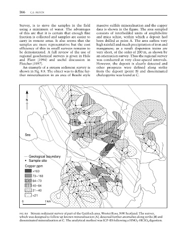
Survey, is to sieve the samples in the field massive sulfide mineralisation and the copper
using a minimum of water. The advantages data is shown in the figure. The area sampled
of this are that it is certain that enough fine consists of interbedded units of amphibolite
fraction is collected and samples are easier to and mica schist, within which a deposit had
carry in remote areas. It also seems that the been drilled at point A. The area suffers very
samples are more representative but the cost high rainfall and much precipitation of iron and
efficiency of this in small surveys remains to manganese; as a result dispersion trains are
be demonstrated. A full review of the use of very short, of the order of 200 m, as shown by
regional geochemical surveys is given in Hale an orientation survey. Thus the regional survey
and Plant (1994) and useful discussion in was conducted at very close-spaced intervals.
Fletcher (1997). However, the deposit is clearly detected and
An example of a stream sediment survey is other prospects were defined along strike
shown in Fig. 8.8. The object was to define fur- from the deposit (point B) and disseminated
ther mineralisation in an area of Besshi style chalcopyrite was found at C.
N
B
Sea
A
Geological boundary
• Sample site
Copper ppm C
>163
73–163
64–73
40–64
21–40
<21
0 1km
FIG. 8.8 Stream sediment survey of part of the Gairloch area, Wester Ross, NW Scotland. The survey,
which was designed to follow up known mineralisation (A), detected further anomalies along strike (B) and
disseminated mineralisation at C. The analytical method was ICP–ES following a HNO 3 –HClO 4 digestion.