
Page 167 - MATLAB Recipes for Earth Sciences
P. 167
162 7 Spatial Data
i.e., we compute a smooth and continuous surface from our measurements
in the fi eld. Surface estimation is typicall carried out in two major steps.
Firstly, the number of control points needs to be selected. Secondly, the grid
points have to be estimated. Control points are irregularly-space fi eld mea-
surements, such as the thicknesses of sandstone units at different outcrops or
the concentrations of a chemical tracer in water wells. The data are generally
represented as xyz triplets, where x and y are spatial coordinates and z is the
variable of interest. In such cases, most gridding methods require continu-
ous and unique data. However, the spatial variables in earth sciences are
often discontinuous and spatially nonunique. As an example, the sandstone
unit may be faulted or folded. Furthermore, gridding requires spatial auto-
correlation. In other words, the neighboring data points should be correlated
with each other by a certain relationship. It is not sensible to use random z
variable for the surface estimation if the data are not autocorrelated. Having
selected the control points, the calculation of the z values at the equally-
spaced grid points varies from method to method.
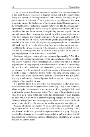
Various techniques exist for selecting the control points (Fig. 7.5a). Most
methods make arbitrary assumptions on the autocorrelation of the z variable.
The nearest-neighbor criterion includes all control points within a circular
neighborhood of the grid point, where the radius of the circle is specifi ed by
the user. Since the spatial autocorrelation is likely to decrease with increas-
ing distance from the grid point, considering too many distant control points
is likely to lead to erroneous results while computing the grid points. On
the other hand, small circular areas limit the calculation of the grid points
to a very small number of control points. Such an approach leads to a noisy
estimate of the modeled surface.
It is perhaps due to these difficulties that triangulation is often used as an
alternative method for selecting the control points (Fig. 7.5b). In this technique,
all control points are connected to a triangular net. Every grid point is located
in a triangular area of three control points. The z value of the grid point is com-
puted from the z values of the grid points. In a modification of such gridding,
the three points at the apices of the three adjoining triangles are also used. The
Delauney triangulation uses the triangular net where the acuteness of the tri-
angles is minimized, i.e., the triangles are as close as possible to equilateral.
Kriging introduced in Chapter 7.9 is an alternative approach of select-
ing control points. It is often regarded as the method of gridding. Some
people even use the term geostatistics synonymous with kriging. Kriging is
a method for determining the spatial autocorrelation and hence the circle di-
mension. More sophisticated versions of kriging use an elliptical area which
includes the control points.