
Page 162 - MATLAB Recipes for Earth Sciences
P. 162
7.4 The 30-Arc Seconds Elevation Model GTOPO30 157
7.4 The 30-Arc Seconds Elevation Model GTOPO30
The 30 arc second (approximately 1 km) global digital elevation data set
GTOPO30 only contains elevation data, not bathymetry. The data set has
been developed by the Earth Resources Observation System Data Center
and is available from the web page
http://edcdaac.usgs.gov/gtopo30/gtopo30.html
The model uses a variety of international data sources. However, it is based
on raster data from the Digital Terrain Elevation Model ( DTEM) and vec-
tor data from the Digital Chart of the World (DCW). The GTOPO30 data
set has been divided into 33 pieces or tiles. The tile names refer to the lon-
gitude and latitude of the upper-left (northwest) corner of the tile. The tile
name e020n40 refers to the upper-left corner of the tile. In our example, the
coordinates of the upper-left corner are 20 degrees eastern longitude and
40 degrees northern latitude. As example, we select and download the tile
e020n40 provided as a 24.9 MB compressed tar fi le. After decompressing
the tar file, we obtain eight files containing the raw data and header fi les in
various formats. Moreover, the file provides a GIF image of a shaded relief
display of the data.
Importing the GTOPO30 data into the workspace is simple. The Mapping
Toolbox provides an import routine gtopo30 that reads the data and stores
it onto a regular data grid. We import only a subset of the original matrix:
latlim = [-5 5]; lonlim = [30 40];
GTOPO30 = gtopo30('E020N40',1,latlim,lonlim);
This script reads the data from the tile e020n40 (without file extension) in
full resolution (scale factor = 1) into the matrix GTOPO30. The coordinate
system is defi ned by using the lon/lat limits as listed above. The resolution
is 30 arc seconds corresponding to 1/120 degrees.
[LON,LAT] = meshgrid(30:1/120:40,-5:1/120:5);
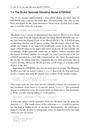
A grayscale image can be generated from the elevation data by using the
function surf. The fourth power of the colormap gray is used for darken-
ing the map at higher levels of elevation. Subsequently, the colormap is
flipped vertically in order to obtain dark colors for high elevations and light
colors for low elevations.
figure
surf(LON,LAT,GTOPO30)
shading interp