
Page 182 - Modern Spatiotemporal Geostatistics
P. 182
Uncertainty Assessment 163
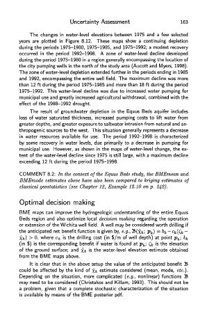
The changes in water-level elevations between 1975 and a few selected
years are plotted in Figure 8.12. These maps show a continuing depletion
during the periods 1975-1980, 1975-1985, and 1975-1992; a modest recovery
occurred in the period 1992-1998. A zone of water-level decline developed
during the period 1975-1980 in a region generally encompassing the location of
the city pumping wells in the north of the study area (Aucott and Myers, 1998).
The zone of water-level depletion extended further in the periods ending in 1985
and 1992, encompassing the entire well field. The maximum decline was more
than 12 ft during the period 1975-1985 and more than 18 ft during the period
1975-1992. This water-level decline was due to increased water pumping for
municipal use and greatly increased agricultural withdrawal, combined with the
effect of the 1988-1992 drought.
The result of groundwater depletion in the Equus Beds aquifer includes
loss of water saturated thickness, increased pumping costs to lift water from
greater depths, and greater exposure to saltwater intrusion from natural and an-
thropogenic sources to the west. This situation generally represents a decrease
in water resources available for use. The period 1992-1998 is characterized
by some recovery in water levels, due primarily to a decrease in pumping for
municipal use. However, as shown in the maps of water-level change, the ex-
tent of the water-level decline since 1975 is still large, with a maximum decline
exceeding 12 ft during the period 1975-1998.
COMMENT 8.2: In th e context of the Equus Beds study, th e BMEmean an d
BMEmode estimates above have also been compared to kriging estimates of
classical geostatistics (see Chapter 12, Example 12.10 on p. 242).
Optimal decision making
BME maps can improve the hydrogeologic understanding of the entire Equus
Beds region and also optimize local decision making regarding the operation
or extension of the Wichita well field. A well may be considered worth drilling if
the anticipated net benefit function is given by, e.g., %>(xk', Pk) = &fc ~Ck((k -
Xk) > 0, where Cfc is the drilling cost (in $/m of well depth) at point p k\ £>/.
(in $) is the corresponding benefit if water is found at p k; & is the elevation
of the ground surface; and Xk is the water-level elevation estimate obtained
from the BME maps above.
It is clear that in the above setup the value of the anticipated benefit B
could be affected by the kind of Xk estimate considered (mean, mode, etc.).
Depending on the situation, more complicated (e.g., nonlinear) functions B
may need to be considered (Christakos and Killam, 1993). This should not be
a problem, given that a complete stochastic characterization of the situation
is available by means of the BME posterior pdf.