
Page 181 - Modern Spatiotemporal Geostatistics
P. 181
162 Modern Spatiotemporal Geostatistics — Chapter 8
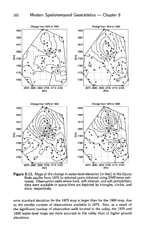
Figure 8.12. Maps of the change in water-level elevation (in feet) in the Equus
Beds aquifer from 1975 to selected years obtained using BMEmean esti-
mates. Observation wells where hard, soft interval, and soft probabilistic
data were available in space/time are depicted by triangles, circles, and
stars, respectively.
error standard deviation for the 1975 map is larger than for the 1998 map, due
to the smaller number of observations available in 1975. Also, as a result of
the significant number of observation wells located in the valley, the 1975 and
1998 water-level maps are more accurate in the valley than at higher ground
elevations.